IMAGES TAKEN NEAR TO
Cleveland Road, NEW MALDEN, KT3 3QQ
Introduction
This page details the photographs taken nearby to Cleveland Road, KT3 3QQ by members of the Geograph project.
The Geograph project started in 2005 with the aim of publishing, organising and preserving representative images for every square kilometre of Great Britain, Ireland and the Isle of Man.

There are currently over 7.5m images from over14,400 individuals and you can help contribute to the project by visiting https://www.geograph.org.uk
Image Map
Images are licensed for reuse under creativecommons.org/licenses/by-sa/2.0
Notes
- Clicking on the map will re-center to the selected point.
- The higher the marker number, the further away the image location is from the centre of the postcode.
Image Listing (44 Images Found)
Images are licensed for reuse under creativecommons.org/licenses/by-sa/2.0
Image
Details
Distance
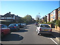
1
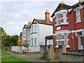
Houses in Gloster Rd
These large Victorian semi-detached houses are in a very short residential cul-de-sac road off Cleveland Road close to its junction with the A2043 Kingston Rd.
Image: © Nigel Mykura
Taken: 30 Oct 2012
0.05 miles
2
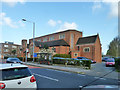
Catholic church, New Malden
St. Joseph's on Kingston Road. The bus stop is called St. Joseph's Church.
Image: © Robin Webster
Taken: 1 Apr 2012
0.07 miles
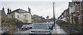
3
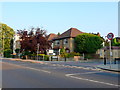
Junction of Sandal Rd and Kingston Rd
At this point the Kingston Rd the A2043 is mainly residential with a mix of flats in small blocks and semi-detached and detached houses. The side roads have a 20 mph speed limit.
Image: © Nigel Mykura
Taken: 21 Jul 2013
0.10 miles
4
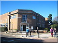
New Malden Library
A good example of 1930s municipal architecture. Grade II Listed http://www.imagesofengland.org.uk/Details/Default.aspx?id=436635&mode=adv.
Image: © Rod Allday
Taken: 15 Oct 2011
0.10 miles
5
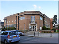
Public library, New Malden
On the corner of Kingston Road and Sandal Road.
Image: © Robin Webster
Taken: 1 Apr 2012
0.10 miles
10
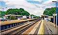
New Malden station, 2001
View east on the Down Main platform; ex-LSWR Waterloo - Woking and the West main line, junction of the branch to Kingston-on-Thames etc. It was badly bombed, together with a local train in the station, on 18 August 1940 in the very first Luftwaffe attack on London: there are plaques in memory of staff killed.
Image: © Ben Brooksbank
Taken: 31 May 2001
0.17 miles