IMAGES TAKEN NEAR TO
Darley Drive, NEW MALDEN, KT3 3AS
Introduction
This page details the photographs taken nearby to Darley Drive, KT3 3AS by members of the Geograph project.
The Geograph project started in 2005 with the aim of publishing, organising and preserving representative images for every square kilometre of Great Britain, Ireland and the Isle of Man.

There are currently over 7.5m images from over14,400 individuals and you can help contribute to the project by visiting https://www.geograph.org.uk
Image Map
Images are licensed for reuse under creativecommons.org/licenses/by-sa/2.0
Notes
- Clicking on the map will re-center to the selected point.
- The higher the marker number, the further away the image location is from the centre of the postcode.
Image Listing (32 Images Found)
Images are licensed for reuse under creativecommons.org/licenses/by-sa/2.0
Image
Details
Distance
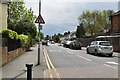
2
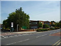
New Malden: Coombe Girls' School and Sixth Form centre
On Clarence Avenue
Image: © Dr Neil Clifton
Taken: 16 Jul 2013
0.07 miles
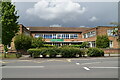
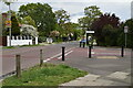
3

Coombe Girls' School
The sign adds 'and Sixth Form Centre'.
Image: © Robin Webster
Taken: 1 Apr 2012
0.07 miles
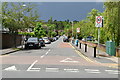
5
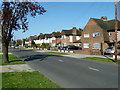
Houses on Clarence Avenue
Part of New Malden suburbia.
Image: © Robin Webster
Taken: 1 Apr 2012
0.09 miles
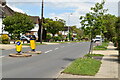
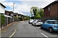
9
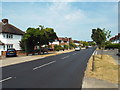
Clarence Avenue, New Malden
Clarence Avenue is a residential road in New Malden, in the outer suburbs of south west London.
The grass verges are yellowish-brown, a sign that there had been no rain for a long time.
Image: © Malc McDonald
Taken: 1 Jul 2018
0.11 miles