IMAGES TAKEN NEAR TO
Grafton Road, NEW MALDEN, KT3 3AA
Introduction
This page details the photographs taken nearby to Grafton Road, KT3 3AA by members of the Geograph project.
The Geograph project started in 2005 with the aim of publishing, organising and preserving representative images for every square kilometre of Great Britain, Ireland and the Isle of Man.

There are currently over 7.5m images from over14,400 individuals and you can help contribute to the project by visiting https://www.geograph.org.uk
Image Map
Images are licensed for reuse under creativecommons.org/licenses/by-sa/2.0
Notes
- Clicking on the map will re-center to the selected point.
- The higher the marker number, the further away the image location is from the centre of the postcode.
Image Listing (89 Images Found)
Images are licensed for reuse under creativecommons.org/licenses/by-sa/2.0
Image
Details
Distance
1
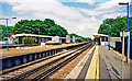
New Malden station, 2001
View east on the Down Main platform; ex-LSWR Waterloo - Woking and the West main line, junction of the branch to Kingston-on-Thames etc. It was badly bombed, together with a local train in the station, on 18 August 1940 in the very first Luftwaffe attack on London: there are plaques in memory of staff killed.
Image: © Ben Brooksbank
Taken: 31 May 2001
0.04 miles
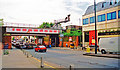
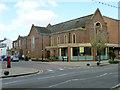
3
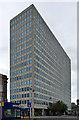
Apex Tower, High Street
An example of suburban London's boom in office space in the 1960s. Like the block over the road (Image]), this dates from 1963-68 and was designed by Planning & Development Limited. It has a reinforced concrete frame.
In total it provides about 110,000 square feet of office space.
Image: © Stephen Richards
Taken: 13 Aug 2011
0.09 miles
4
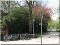
The Cut, New Malden
A footpath and cycleway running parallel to the railway line and linking Coombe Road with Elm Road.
Image: © Stephen Craven
Taken: 22 Apr 2010
0.10 miles
5
Malden High Street, at New Malden station 2001
View northward, with the station on the right; ex-LSWR Waterloo - Wimbledon - Woking and the West, junction of lines to Kingston, Shepperton and Richmond.
Image: © Ben Brooksbank
Taken: 31 May 2001
0.10 miles
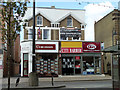
6
Market Place, New Malden
The street name plate on the corner of this block is 'Market Place', on the High Street side. Was this the name of part of the High Street, or just of this block?
Image: © Robin Webster
Taken: 1 Apr 2012
0.10 miles
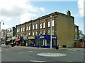
8
High Street architecture, New Malden
This seems to have been a pair of houses dating from the mid 1800s, along with another pair to the left, probably similar, now gone. The High Street was then called Trap's Lane.
Image: © Robin Webster
Taken: 1 Apr 2012
0.11 miles
9
Methodist Church, New Malden
On the corner of High Street and Cambridge Road.
Image: © Robin Webster
Taken: 1 Apr 2012
0.11 miles
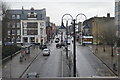
10
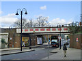
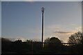
Railway bridge, New Malden
In fact two bridges, each carrying two tracks of the four track main Waterloo line.
Image: © Robin Webster
Taken: 1 Apr 2012
0.11 miles