IMAGES TAKEN NEAR TO
Deer Park Close, KINGSTON UPON THAMES, KT2 7TW
Introduction
This page details the photographs taken nearby to Deer Park Close, KT2 7TW by members of the Geograph project.
The Geograph project started in 2005 with the aim of publishing, organising and preserving representative images for every square kilometre of Great Britain, Ireland and the Isle of Man.

There are currently over 7.5m images from over14,400 individuals and you can help contribute to the project by visiting https://www.geograph.org.uk
Image Map
Images are licensed for reuse under creativecommons.org/licenses/by-sa/2.0
Notes
- Clicking on the map will re-center to the selected point.
- The higher the marker number, the further away the image location is from the centre of the postcode.
Image Listing (80 Images Found)
Images are licensed for reuse under creativecommons.org/licenses/by-sa/2.0
Image
Details
Distance
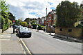
1
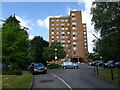
High Ashton
Block of flats, Kingston upon Thames.
Image: © JThomas
Taken: 27 May 2022
0.08 miles
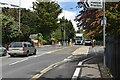
2
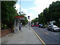
Bus stop and shelter on Kingston Hill, Kingston upon Thames
Image: © JThomas
Taken: 27 May 2022
0.10 miles
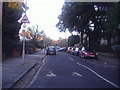
3
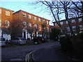
Heatherdale Close, Kingston-Upon-Thames
Image: © David Howard
Taken: 9 Jan 2011
0.11 miles
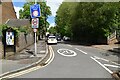
6
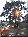
Tree on the corner of Crescent Road, Kingston
Image: © David Howard
Taken: 19 Dec 2016
0.13 miles
9
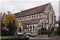
St.Paul's
Seen from Cherrywood Close.
Image: © Peter Trimming
Taken: 21 Nov 2017
0.14 miles
10
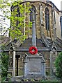
War Memorial, corner of Alexandra Road and Queens Road, Kingston Hill
The memorial is dedicated to the fallen of both World Wars. It is outside St. Paul's Church.
Image
Image: © L S Wilson
Taken: 18 May 2010
0.14 miles