IMAGES TAKEN NEAR TO
Kingsnympton Park, KINGSTON UPON THAMES, KT2 7TF
Introduction
This page details the photographs taken nearby to Kingsnympton Park, KT2 7TF by members of the Geograph project.
The Geograph project started in 2005 with the aim of publishing, organising and preserving representative images for every square kilometre of Great Britain, Ireland and the Isle of Man.

There are currently over 7.5m images from over14,400 individuals and you can help contribute to the project by visiting https://www.geograph.org.uk
Image Map
Images are licensed for reuse under creativecommons.org/licenses/by-sa/2.0
Notes
- Clicking on the map will re-center to the selected point.
- The higher the marker number, the further away the image location is from the centre of the postcode.
Image Listing (47 Images Found)
Images are licensed for reuse under creativecommons.org/licenses/by-sa/2.0
Image
Details
Distance
1
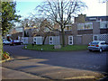
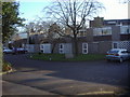
Astor Close, Coombe
Modern 1960s housing development on the edge of Richmond Park
Image: © David Howard
Taken: 17 Feb 2008
0.09 miles
3
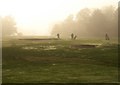
Coombe Wood Golf Course
A zoomed version of the scene in Image, as golfers move past bunkers towards the green. The dew in the foreground is really melted frost.
Image: © Derek Harper
Taken: 16 Nov 2010
0.13 miles
4
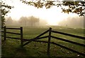
Coombe Wood Golf Course
A view on a misty day from Warren Road. To the right of the bunkers is the northernmost green on the course.
Image: © Derek Harper
Taken: 16 Nov 2010
0.13 miles
5
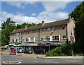
Canbury School
The blue plaque records that Sir Malcolm and Donald Campbell, world land and water speed record holders, once lived here.
Image: © Robin Webster
Taken: 22 Apr 2012
0.13 miles
6
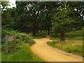
Paths in Richmond Park
In this image, a path used for walking and cycling crosses a track used for horse riding.
Image: © Malc McDonald
Taken: 9 Jul 2016
0.14 miles
7
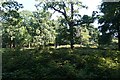
Woodland near the Queen's Road entrance, Richmond Park
Image: © Mike Pennington
Taken: 11 Aug 2017
0.14 miles
8
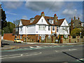
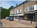
Shops on Crescent Road, Kingston upon Thames
Image: © JThomas
Taken: 27 May 2022
0.14 miles
10
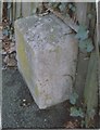
Old Milestone by the A308, Kingston Hill, Coombe, Kingston upon Thames parish
Carved stone post by the A308 (was A3), in parish of KINGSTON UPON THAMES (KINGSTON UPON THAMES District), Kingston Hill, Coombe, by garden of No. 124, Newgale, 40m East of junction with Warboys Approach, in tarmac surrounded by wooden board fence, on East side of road. Surrey limestone pillar, erected by the Surrey & Sussex turnpike trust in the 19th century.
Inscription reads:-
: ROYAL / EXCHANGE / 11 : : WHITEHALL / 10½ / MILES :
Carved benchmark and rivet on top.
Milestone Society National ID: SY_LP10.
Image: © C Woodward
Taken: 13 Nov 2004
0.16 miles