IMAGES TAKEN NEAR TO
Heatherdale Close, KINGSTON UPON THAMES, KT2 7SU
Introduction
This page details the photographs taken nearby to Heatherdale Close, KT2 7SU by members of the Geograph project.
The Geograph project started in 2005 with the aim of publishing, organising and preserving representative images for every square kilometre of Great Britain, Ireland and the Isle of Man.

There are currently over 7.5m images from over14,400 individuals and you can help contribute to the project by visiting https://www.geograph.org.uk
Image Map
Images are licensed for reuse under creativecommons.org/licenses/by-sa/2.0
Notes
- Clicking on the map will re-center to the selected point.
- The higher the marker number, the further away the image location is from the centre of the postcode.
Image Listing (64 Images Found)
Images are licensed for reuse under creativecommons.org/licenses/by-sa/2.0
Image
Details
Distance
1
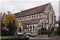
St.Paul's
Seen from Cherrywood Close.
Image: © Peter Trimming
Taken: 21 Nov 2017
0.01 miles
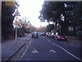
2
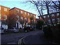
Heatherdale Close, Kingston-Upon-Thames
Image: © David Howard
Taken: 9 Jan 2011
0.02 miles
3
The Tamsin Trail ascends Dark Hill, Richmond Park
The Tamsin Trail was laid out in the 1980's, in an attempt to contain the activities of mountain-bikers (the mountain bike being a fairly new invention at the time). It was not foreseen that the gravelled surface would prove popular with folk pushing baby-buggies and the like - inevitably giving rise to friction between the various users.
As a cyclist, I'm not keen on the gravelled surface - grip isn't that stable on bends, gravel chews up all but the toughest tyres, and if you fall off, sharp gravel is about the last surface you want to land on.
Richmond Park is a National Nature Reserve.
Image: © Stefan Czapski
Taken: 3 May 2012
0.07 miles
4
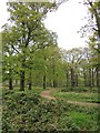
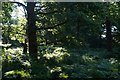
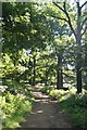
Woodland near the Queen's Road entrance, Richmond Park
Image: © Mike Pennington
Taken: 11 Aug 2017
0.09 miles
5
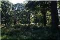
Woodland near the Queen's Road entrance, Richmond Park
Image: © Mike Pennington
Taken: 11 Aug 2017
0.11 miles
6
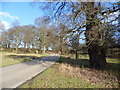
Richmond Park near Kings Clump
Richmond Park is London's largest National Nature Reserve. It is notable for its wonderful array of trees. This view is looking towards Kings Clump on the left of the road, not far from Kingston Gate.
Image: © Marathon
Taken: 30 Jan 2013
0.11 miles
7
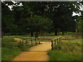
Bridge over a stream, Richmond Park
This bridge carries a path over a stream in Richmond Park. The path is used for walking and cycling.
Image: © Malc McDonald
Taken: 9 Jul 2016
0.11 miles
8
Woodland near the Queen's Road entrance, Richmond Park
Image: © Mike Pennington
Taken: 11 Aug 2017
0.13 miles
10
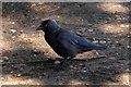
Jackdaw (Corvus monedula), Queen's Road car park, Richmond Park
The policy of leaving dead wood for invertebrates such as Stag Beetles also benefits hole-nesting birds like Jackdaws.
Image: © Mike Pennington
Taken: 11 Aug 2017
0.14 miles