IMAGES TAKEN NEAR TO
Kingston Hill, KT2 7FR
Introduction
This page details the photographs taken nearby to Kingston Hill, KT2 7FR by members of the Geograph project.
The Geograph project started in 2005 with the aim of publishing, organising and preserving representative images for every square kilometre of Great Britain, Ireland and the Isle of Man.

There are currently over 7.5m images from over14,400 individuals and you can help contribute to the project by visiting https://www.geograph.org.uk
Image Map
Images are licensed for reuse under creativecommons.org/licenses/by-sa/2.0
Notes
- Clicking on the map will re-center to the selected point.
- The higher the marker number, the further away the image location is from the centre of the postcode.
Image Listing (105 Images Found)
Images are licensed for reuse under creativecommons.org/licenses/by-sa/2.0
Image
Details
Distance
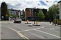
1
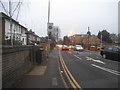
Queens Road, Kingston
It leads to Richmond Park during its opening hours.
Image: © David Howard
Taken: 19 Dec 2016
0.02 miles
3
Wolverton Avenue looking towards Coombe Road
Image: © David Howard
Taken: 19 Dec 2016
0.04 miles
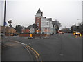
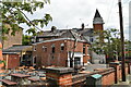
6
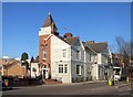
The Albert, Norbiton
An eye catching Victorian pub on Kingston Hill dating from 1855.
Part of the Young's Brewery estate.
Image: © Des Blenkinsopp
Taken: 18 Feb 2015
0.04 miles
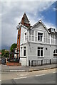
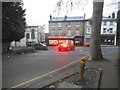
8
The Albert, Kingston upon Thames
On Kingston Hill.
See Image] for sign.
Image: © JThomas
Taken: 27 May 2022
0.04 miles
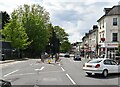
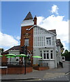
10
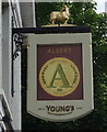
Sign for the Albert, Kingston upon Thames
See Image] for context.
Image: © JThomas
Taken: 27 May 2022
0.05 miles