IMAGES TAKEN NEAR TO
Lovekyn Close, KINGSTON UPON THAMES, KT2 6RY
Introduction
This page details the photographs taken nearby to Lovekyn Close, KT2 6RY by members of the Geograph project.
The Geograph project started in 2005 with the aim of publishing, organising and preserving representative images for every square kilometre of Great Britain, Ireland and the Isle of Man.

There are currently over 7.5m images from over14,400 individuals and you can help contribute to the project by visiting https://www.geograph.org.uk
Image Map
Images are licensed for reuse under creativecommons.org/licenses/by-sa/2.0
Notes
- Clicking on the map will re-center to the selected point.
- The higher the marker number, the further away the image location is from the centre of the postcode.
Image Listing (191 Images Found)
Images are licensed for reuse under creativecommons.org/licenses/by-sa/2.0
Image
Details
Distance
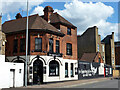
2
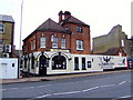
The Fighting Cocks, Kingston upon Thames
The traditional market town pub has been decimated in Kingston upon Thames. Added to this tale of woe are pubs like the Fighting Cocks which only sells pretend lager and not a drop of proper beer.
Image: © al partington
Taken: 23 Mar 2008
0.03 miles
3
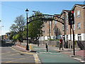
Cycleway on Old London Road
As the name implies, Old London Road was formerly the principal route out of Kingston towards London. This section of it is now closed to through traffic and used as a cycleway.
Image: © Stephen Craven
Taken: 26 Apr 2009
0.03 miles
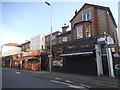
4
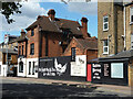
The Fighting Cocks - rear view (2012)
Looking from Fairfield North, which runs closely parallel with Old London Road, where the front of the pub may be found. The same goes for the adjacent tattoo parlour.
Image: © Robin Webster
Taken: 26 Aug 2012
0.04 miles
5
The Fighting Cocks - rear view (2012)
Looking from Fairfield North, which runs closely parallel with Old London Road, where the front of the pub may be found.
Image: © Robin Webster
Taken: 26 Aug 2012
0.04 miles
7
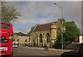
Lovekyn Chapel, Kingston
Seen across the busy A308 London Road between vehicles. I'm just changing buses, though I didn't get off the 131, but couldn't resist this view of the chapel also shown in http://www.geograph.org.uk/search.php?i=41946824 . The listed building description is at http://list.english-heritage.org.uk/resultsingle.aspx?uid=1358425&searchtype=mapsearch , where it is known as the Chantry Chapel of St Mary Magdalene. The flats across Queen Elizabeth Road are in Lovekyn Close.
Image: © Derek Harper
Taken: 10 May 2013
0.04 miles
8
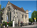
The Lovekyn Chapel, Kingston
The chapel dates from 1309, and has an interesting history (see Image for more detail). Although now part of Kingston Grammar School across the road, it is still used for carol concerts and other religious services. Its 700th anniversary was being celebrated with an exhibition nearby at the time this photo was taken.
Image: © Stephen Craven
Taken: 26 Apr 2009
0.05 miles
9
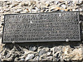
History of the Lovekyn Chapel
A plaque on the wall of the chapel Image giving its history.
Image: © Stephen Craven
Taken: 26 Apr 2009
0.05 miles
10
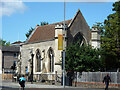
The Lovekyn Chapel, Kingston upon Thames
A grade II*(star) listed building, 1309 origins, partly rebuilt 1352 and 1886.
Image: © Robin Webster
Taken: 26 Aug 2012
0.05 miles