IMAGES TAKEN NEAR TO
Clifton Road, KINGSTON UPON THAMES, KT2 6PL
Introduction
This page details the photographs taken nearby to Clifton Road, KT2 6PL by members of the Geograph project.
The Geograph project started in 2005 with the aim of publishing, organising and preserving representative images for every square kilometre of Great Britain, Ireland and the Isle of Man.

There are currently over 7.5m images from over14,400 individuals and you can help contribute to the project by visiting https://www.geograph.org.uk
Image Map
Images are licensed for reuse under creativecommons.org/licenses/by-sa/2.0
Notes
- Clicking on the map will re-center to the selected point.
- The higher the marker number, the further away the image location is from the centre of the postcode.
Image Listing (50 Images Found)
Images are licensed for reuse under creativecommons.org/licenses/by-sa/2.0
Image
Details
Distance
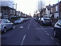
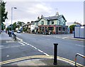
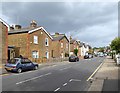
2
Park Road, Kingston
The road on the right is closed for the women's road race, which went along the parallel Queen's Road.
Image: © Hugh Venables
Taken: 29 Jul 2012
0.12 miles
3
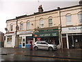
Shops on Park Road, Kingston
My first photo of 2017, taken at 2.18PM
Image: © David Howard
Taken: 1 Jan 2017
0.12 miles
4
Shortlands Road, Kingston
A view from the junction with Cross Road along this suburban road. On the immediate left, in different character, is Macdonald House, a block of flats.
Image: © Derek Harper
Taken: 14 Jun 2010
0.13 miles
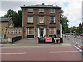
5
The Pottery, Park Road
Restaurant and tapas bar in north Kingston.
Image: © Hugh Venables
Taken: 29 Jul 2012
0.13 miles
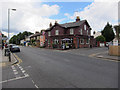
6
Alexandra, closed
According to http://www.beerintheevening.com/pubs/s/11/1190/Alexandra/Norbiton it has been closed several times. Not clear what will happen next.
Image: © Hugh Venables
Taken: 29 Jul 2012
0.13 miles
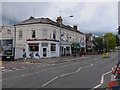
7
Kingston: Park Road and The Pottery
The Pottery - at the corner of Borough Road - is a substantial former pub that must date from about 1900. It now trades as a tapas bar.
The name Park Road no doubt derives from the fact that the road leads towards Richmond Park from the foot of Kingston Hill.
The photo was taken on a quiet Sunday evening, but bollards and yellow lines are evidence of traffic blight and parking problems.
Image: © Stefan Czapski
Taken: 16 Jun 2019
0.13 miles
8
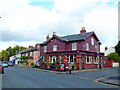
The Pottery Pub
This unusually painted purple pub is on the corner of Borough Rd (on the right) and Park Rd ( in the foreground.)
Image: © Nigel Mykura
Taken: 30 Oct 2012
0.14 miles
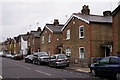
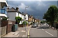
10
King's Road, Kingston, September 2017
Very solid-looking Victorian semis - with barge-boarded gables facing the street - are typical of these streets on the north side of Kingston.
Along this stretch of King's Road each pair of houses has a date-panel up in the gable. Most are no longer legible, but one (nearer Kingston Gate) reads "Emma's Cottages 1870". Plainly this area of Kingston was laid out at about that time, as the old East Surrey Barracks (a couple of hundred yards behind the camera) carry the date 1875.
Image: © Stefan Czapski
Taken: 6 Sep 2017
0.16 miles