IMAGES TAKEN NEAR TO
Craven Road, KINGSTON UPON THAMES, KT2 6LW
Introduction
This page details the photographs taken nearby to Craven Road, KT2 6LW by members of the Geograph project.
The Geograph project started in 2005 with the aim of publishing, organising and preserving representative images for every square kilometre of Great Britain, Ireland and the Isle of Man.

There are currently over 7.5m images from over14,400 individuals and you can help contribute to the project by visiting https://www.geograph.org.uk
Image Map
Images are licensed for reuse under creativecommons.org/licenses/by-sa/2.0
Notes
- Clicking on the map will re-center to the selected point.
- The higher the marker number, the further away the image location is from the centre of the postcode.
Image Listing (20 Images Found)
Images are licensed for reuse under creativecommons.org/licenses/by-sa/2.0
Image
Details
Distance
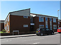
2
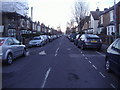
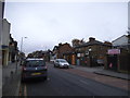
Kingston: Canbury Park Road
19th-century residential development in this part of Kingston was somewhat piece-meal - the uniformity of the terrace on the right is not typical.
Image: © Stefan Czapski
Taken: 16 Jun 2019
0.13 miles
3
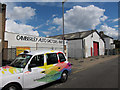
Camberley Auto Factors
Former branch on Elton Road.
Image: © Hugh Venables
Taken: 29 Jul 2012
0.18 miles
4
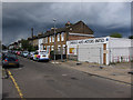
Camberley Auto Factors
Closed branch on Elton Road.
Image: © Hugh Venables
Taken: 29 Jul 2012
0.18 miles
5
Dowler Court
A sheltered housing block on the corner of Burton Road and acre Road, Kingston-upon-Thames.
Image: © Stephen Craven
Taken: 3 May 2013
0.18 miles
6
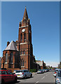
St Luke's church, Kingston-upon-Thames: south end
An Anglican church in the Anglo-Catholic tradition. The brick building, with a prominent spire, was built in 1888-91, designed by Edward Birchall and John Kelly and is listed grade 2 (list entry number 1391818). It sits astride the grid line. This is the geographical south end, liturgical east, facing Burton Road. See also Image
Image: © Stephen Craven
Taken: 3 May 2013
0.19 miles
7
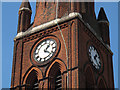
St Luke's church, Kingston-upon-Thames: clock faces
Two of the clock faces on this tall church spire. For context, see Image
Image: © Stephen Craven
Taken: 3 May 2013
0.19 miles
8
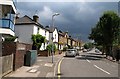
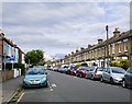
Shortlands Road, Kingston
A view from the junction with Cross Road along this suburban road. On the immediate left, in different character, is Macdonald House, a block of flats.
Image: © Derek Harper
Taken: 14 Jun 2010
0.20 miles
10
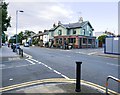
Kingston: Park Road and The Pottery
The Pottery - at the corner of Borough Road - is a substantial former pub that must date from about 1900. It now trades as a tapas bar.
The name Park Road no doubt derives from the fact that the road leads towards Richmond Park from the foot of Kingston Hill.
The photo was taken on a quiet Sunday evening, but bollards and yellow lines are evidence of traffic blight and parking problems.
Image: © Stefan Czapski
Taken: 16 Jun 2019
0.20 miles