IMAGES TAKEN NEAR TO
Sigrist Square, KINGSTON UPON THAMES, KT2 6JY
Introduction
This page details the photographs taken nearby to Sigrist Square, KT2 6JY by members of the Geograph project.
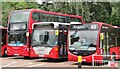
The Geograph project started in 2005 with the aim of publishing, organising and preserving representative images for every square kilometre of Great Britain, Ireland and the Isle of Man.

There are currently over 7.5m images from over14,400 individuals and you can help contribute to the project by visiting https://www.geograph.org.uk
Image Map
Images are licensed for reuse under creativecommons.org/licenses/by-sa/2.0
Notes
- Clicking on the map will re-center to the selected point.
- The higher the marker number, the further away the image location is from the centre of the postcode.
Image Listing (151 Images Found)
Images are licensed for reuse under creativecommons.org/licenses/by-sa/2.0
Image
Details
Distance
1
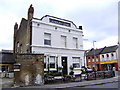
Canbury Arms, Kingston upon Thames
Very much a Gastro pub but offers a good range of beers too such as Old Hooky from Oxfordshire's splendid Hook Norton brewery.
Image: © al partington
Taken: 23 Mar 2008
0.03 miles
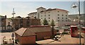
2
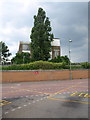
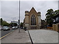
Siddeley House, Kingston
This steel-framed building overlooking Kingston bus station (foreground) is the former Hawker Aircraft Experimental Shop, built in 1933, and associated with the development of the Hurricane. It is now offices, but at least has been retained and listed - most of the factory premises have been redeveloped. http://www.imagesofengland.org.uk/Details/Default.aspx?id=474224&mode=adv
Image: © Derek Harper
Taken: 14 Jun 2010
0.05 miles
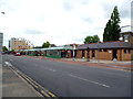
3
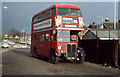
The End Of The Road
At the back of Kingston Bus Depot, which occupied the site of the old Kingston coal yard, RT4442 stands between training duties. It was in its last few days of service and would be withdrawn by the end of the month. Subsequently the bus was bought by a private owner and is currently undergoing restoration.
To the right, the tops of the houses on Cromwell Road are visible whilst on the left the rest of the yard is in use as a car park. The car park area is now given over to modern housing whilst the old depot has become a modern bus station.
Image: © Martin Addison
Taken: Unknown
0.05 miles
4
Kingston - Cromwell Road Bus Depot
Busy local transport node in SW London.
Image: © Colin Smith
Taken: 8 Aug 2017
0.06 miles
5
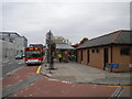
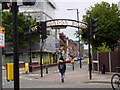
Cromwell Road bus station, Kingston (2)
For some reason, Kingston has two bus stations; Cromwell Road is the main one, served by nearly all routes that serve Kingston town centre. There are four drive through bays on Cromwell Road (left), and 13 drive in/reverse out bays in the bus station proper.
Image: © Richard Vince
Taken: 24 Oct 2015
0.07 miles
6
Cromwell Road Bus Station, Kingston upon Thames
Image: © Chris
Taken: 17 Jul 2017
0.07 miles
7
Kingston: Bus Station, Cromwell Street
A well-designed bus station which is served by through eastbound buses along Cromwell Street, and also buses which terinate here. There are public toilets, a feature often neglected in modern planning.
Image: © Dr Neil Clifton
Taken: 11 May 2013
0.07 miles
9
Kingston: Old London Road, looking west
Image: © Dr Neil Clifton
Taken: 12 May 2018
0.08 miles