IMAGES TAKEN NEAR TO
Richmond Park Road, KINGSTON UPON THAMES, KT2 6AG
Introduction
This page details the photographs taken nearby to Richmond Park Road, KT2 6AG by members of the Geograph project.
The Geograph project started in 2005 with the aim of publishing, organising and preserving representative images for every square kilometre of Great Britain, Ireland and the Isle of Man.

There are currently over 7.5m images from over14,400 individuals and you can help contribute to the project by visiting https://www.geograph.org.uk
Image Map
Images are licensed for reuse under creativecommons.org/licenses/by-sa/2.0
Notes
- Clicking on the map will re-center to the selected point.
- The higher the marker number, the further away the image location is from the centre of the postcode.
Image Listing (21 Images Found)
Images are licensed for reuse under creativecommons.org/licenses/by-sa/2.0
Image
Details
Distance
1
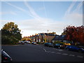
End of Richmond Park Road
Sunrise photograph with aircraft vapour trails.
Image: © James Emmans
Taken: 24 Jul 2016
0.03 miles
2
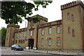
The Old East Surrey Barracks
This building in King's Road is the entrance to the old East Surrey Barracks. Most of the land is now a housing estate
Image: © steve
Taken: 14 May 2005
0.04 miles
3
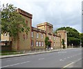
Former East Surrey Barracks, King's Road
Much of the site is now occupied by residential development - known as The Keep.
Image: © Stefan Czapski
Taken: 6 Sep 2017
0.04 miles
4
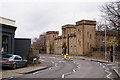
The Barracks, Kingston
In use from 1875 - 1959. The keep was retained, whilst most of the site was developed for housing, following demolition in 1962. In 2011 a developer submitted proposals to convert the keep into flats.
Image: © Peter Trimming
Taken: 21 Nov 2017
0.04 miles
5
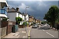
Shortlands Road, Kingston
A view from the junction with Cross Road along this suburban road. On the immediate left, in different character, is Macdonald House, a block of flats.
Image: © Derek Harper
Taken: 14 Jun 2010
0.07 miles
6
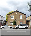
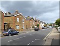
Victorian semis, King's Road Kingston
Image: © Stefan Czapski
Taken: 6 Sep 2017
0.13 miles
8
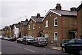
King's Road, Kingston, September 2017
Very solid-looking Victorian semis - with barge-boarded gables facing the street - are typical of these streets on the north side of Kingston.
Along this stretch of King's Road each pair of houses has a date-panel up in the gable. Most are no longer legible, but one (nearer Kingston Gate) reads "Emma's Cottages 1870". Plainly this area of Kingston was laid out at about that time, as the old East Surrey Barracks (a couple of hundred yards behind the camera) carry the date 1875.
Image: © Stefan Czapski
Taken: 6 Sep 2017
0.15 miles
9
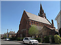
St Luke's church, Kingston-upon-Thames: north end
An Anglican church in the Anglo-Catholic tradition. The brick building, with a prominent spire, was built in 1888-91, designed by Edward Birchall and John Kelly and is listed grade 2 (list entry number 1391818). It sits astride the grid line. This is the geographical north end, liturgical west, facing Gibbon Road. See also Image
Image: © Stephen Craven
Taken: 3 May 2013
0.19 miles
10
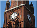
St Luke's church, Kingston-upon-Thames: clock faces
Two of the clock faces on this tall church spire. For context, see Image
Image: © Stephen Craven
Taken: 3 May 2013
0.20 miles