IMAGES TAKEN NEAR TO
KT2 5XE
Introduction
This page details the photographs taken nearby to KT2 5XE by members of the Geograph project.
The Geograph project started in 2005 with the aim of publishing, organising and preserving representative images for every square kilometre of Great Britain, Ireland and the Isle of Man.

There are currently over 7.5m images from over14,400 individuals and you can help contribute to the project by visiting https://www.geograph.org.uk
Image Map
Images are licensed for reuse under creativecommons.org/licenses/by-sa/2.0
Notes
- Clicking on the map will re-center to the selected point.
- The higher the marker number, the further away the image location is from the centre of the postcode.
Image Listing (72 Images Found)
Images are licensed for reuse under creativecommons.org/licenses/by-sa/2.0
Image
Details
Distance
1
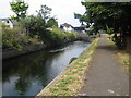
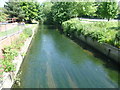
Villiers Road bridge over Hogsmill, Kingston upon Thames
Dead straight reach of Hogsmill, looking downstream along hard bank.
Image: © Julian Smith
Taken: 30 Jun 2006
0.02 miles
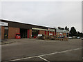
2
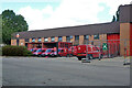
Royal Mail depot, Kingston upon Thames
Image: © Robin Webster
Taken: 26 Aug 2012
0.02 miles
3
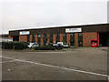
Volante Ltd
Supplying flooring material to trade customers.
Image: © Hugh Venables
Taken: 30 Jan 2015
0.03 miles
4
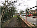
Path by the Hogsmill
Past the Post Office depot.
Image: © Hugh Venables
Taken: 30 Jan 2015
0.03 miles
5
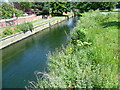
Hogsmill River seen from Villiers Avenue
The Hogsmill River is a chalk stream since most of its water comes from the dip-slope springs at Ewell. Much of its course now forms a wildlife corridor followed by the London LOOP on its way to Kingston Bridge. In the centre of Kingston, the corridor is narrow and the river is largely in a concrete channel but it is still attractive in places. This is the view upriver from the bridge carrying Villiers Avenue over the Hogsmill.
Image: © Marathon
Taken: 5 Jun 2013
0.04 miles
6
Hogsmill River from Villiers Avenue
The Hogsmill River is a chalk stream since most of its water comes from the dip-slope springs at Ewell. Much of its course now forms a wildlife corridor followed by the London LOOP on its way to Kingston Bridge. In the centre of Kingston, the corridor is narrow and the river is largely in a concrete channel but it is still attractive in places. This is the view upriver from the bridge carrying Villiers Avenue over the Hogsmill.
Image: © Marathon
Taken: 5 Jun 2013
0.05 miles
7
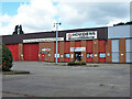
Howdens, Fairfield Trade Park, Kingston upon Thames
Image: © Robin Webster
Taken: 26 Aug 2012
0.05 miles
9
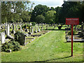
Kingston Cemetery
Looking from the Dawson Road entrance.
Image: © Robin Webster
Taken: 26 Aug 2012
0.06 miles
10
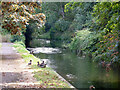
Howdens Joinery
By the River Hogsmill off Villiers Road.
Image: © Hugh Venables
Taken: 30 Jan 2015
0.06 miles