IMAGES TAKEN NEAR TO
Barnfield Avenue, KINGSTON UPON THAMES, KT2 5RE
Introduction
This page details the photographs taken nearby to Barnfield Avenue, KT2 5RE by members of the Geograph project.
The Geograph project started in 2005 with the aim of publishing, organising and preserving representative images for every square kilometre of Great Britain, Ireland and the Isle of Man.

There are currently over 7.5m images from over14,400 individuals and you can help contribute to the project by visiting https://www.geograph.org.uk
Image Map
Images are licensed for reuse under creativecommons.org/licenses/by-sa/2.0
Notes
- Clicking on the map will re-center to the selected point.
- The higher the marker number, the further away the image location is from the centre of the postcode.
Image Listing (55 Images Found)
Images are licensed for reuse under creativecommons.org/licenses/by-sa/2.0
Image
Details
Distance
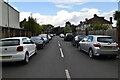
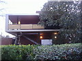
2
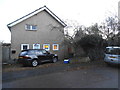
House on Ham Farm Road, Ham
These are all architect designed houses from the 60s, and when the side of the house can be seen from the road this has been made more interesting as well.
Image: © David Howard
Taken: 10 Nov 2014
0.08 miles
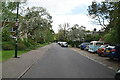
6
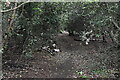
The entrance to Ham Common Woods on Ham Farm Road
Image: © David Howard
Taken: 10 Nov 2014
0.11 miles
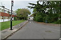
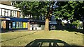
7
Side of Ham Parade
Stairs with the access to the flats above Ham Parade from Parkleys.
Image: © David Howard
Taken: 13 Dec 2010
0.11 miles
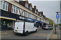
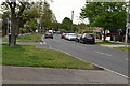
8
Ham Parade
At the corner of Dukes Avenue
Image: © David Howard
Taken: 6 Aug 2016
0.12 miles