IMAGES TAKEN NEAR TO
Woodcote Close, KINGSTON UPON THAMES, KT2 5LZ
Introduction
This page details the photographs taken nearby to Woodcote Close, KT2 5LZ by members of the Geograph project.
The Geograph project started in 2005 with the aim of publishing, organising and preserving representative images for every square kilometre of Great Britain, Ireland and the Isle of Man.

There are currently over 7.5m images from over14,400 individuals and you can help contribute to the project by visiting https://www.geograph.org.uk
Image Map
Images are licensed for reuse under creativecommons.org/licenses/by-sa/2.0
Notes
- Clicking on the map will re-center to the selected point.
- The higher the marker number, the further away the image location is from the centre of the postcode.
Image Listing (29 Images Found)
Images are licensed for reuse under creativecommons.org/licenses/by-sa/2.0
Image
Details
Distance
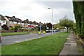
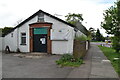
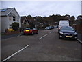
3
Park Road Kingston
The dead end part along the edge of Richmond Park
Image: © David Howard
Taken: 13 Dec 2010
0.09 miles
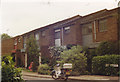
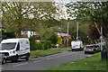
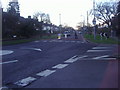
5
Wingfield Road, Kingston
The trees behind are in Richmond Park. You very rarely see light brown roads with tar joints any more but used to be common on suburban roads before the 80s.
Image: © David Howard
Taken: 18 Nov 2013
0.11 miles
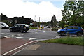
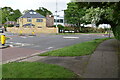
6
Mini Roundabout on Park Road Kingston-Upon-Thames
Image: © David Howard
Taken: 9 Jan 2011
0.12 miles