IMAGES TAKEN NEAR TO
Fernhill Gardens, KINGSTON UPON THAMES, KT2 5DL
Introduction
This page details the photographs taken nearby to Fernhill Gardens, KT2 5DL by members of the Geograph project.
The Geograph project started in 2005 with the aim of publishing, organising and preserving representative images for every square kilometre of Great Britain, Ireland and the Isle of Man.

There are currently over 7.5m images from over14,400 individuals and you can help contribute to the project by visiting https://www.geograph.org.uk
Image Map
Images are licensed for reuse under creativecommons.org/licenses/by-sa/2.0
Notes
- Clicking on the map will re-center to the selected point.
- The higher the marker number, the further away the image location is from the centre of the postcode.
Image Listing (48 Images Found)
Images are licensed for reuse under creativecommons.org/licenses/by-sa/2.0
Image
Details
Distance
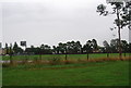
2
Tiffin Girl's School, Kingston
The modern part on the right replaced the half burnt by a fire a few years before, it originally matched the other side.
Image: © David Howard
Taken: 22 Dec 2013
0.12 miles
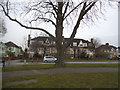
3
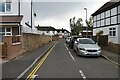
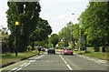
Lower Ham Road, Kingston
Looking towards Richmond Road
Image: © David Howard
Taken: 24 Apr 2018
0.13 miles
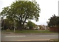
4
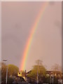
Rainbow over Lower Ham Road, Kingston
It was a complete one but this was the widest part
Image: © David Howard
Taken: 27 Apr 2013
0.15 miles
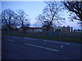
9
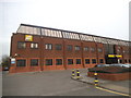
Nikon offices on Richmond Road, Kingston
Image: © David Howard
Taken: 29 Feb 2016
0.17 miles