IMAGES TAKEN NEAR TO
Kingsgate Road, KINGSTON UPON THAMES, KT2 5AA
Introduction
This page details the photographs taken nearby to Kingsgate Road, KT2 5AA by members of the Geograph project.
The Geograph project started in 2005 with the aim of publishing, organising and preserving representative images for every square kilometre of Great Britain, Ireland and the Isle of Man.

There are currently over 7.5m images from over14,400 individuals and you can help contribute to the project by visiting https://www.geograph.org.uk
Image Map
Images are licensed for reuse under creativecommons.org/licenses/by-sa/2.0
Notes
- Clicking on the map will re-center to the selected point.
- The higher the marker number, the further away the image location is from the centre of the postcode.
Image Listing (252 Images Found)
Images are licensed for reuse under creativecommons.org/licenses/by-sa/2.0
Image
Details
Distance
1
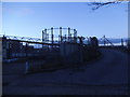
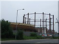
Gas holder behind Richmond Road, Kingston
This is the final one left of the original three.
Image: © David Howard
Taken: 22 Dec 2013
0.03 miles
2
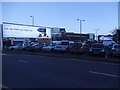
Car Park behind Richmond Road, Kingston
The large building opposite was originally a cinema and became a bingo hall, and is now empty.
Image: © David Howard
Taken: 22 Dec 2013
0.04 miles
3
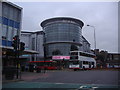
Rotunda Kingston
This is directly opposite Kingston station.
Image: © David Howard
Taken: 13 Oct 2008
0.06 miles
7
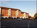
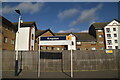
Empty Carpark opposite Flats on Sopwith Way
Image: © James Emmans
Taken: 24 Jul 2016
0.06 miles
8
Gas holders in Kingston
Gas holders, seen from Sury Basin
Image: © Malc McDonald
Taken: 6 Jun 2010
0.06 miles
9
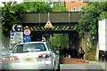
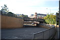
Kingsgate Road runs under a railway bridge
Image: © Steve Daniels
Taken: 30 May 2015
0.06 miles
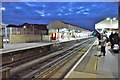
10
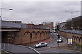
Kingston
View towards the railway station.
Image: © Peter Trimming
Taken: 21 Nov 2017
0.07 miles