IMAGES TAKEN NEAR TO
Ripley Lane, LEATHERHEAD, KT24 6JL
Introduction
This page details the photographs taken nearby to Ripley Lane, KT24 6JL by members of the Geograph project.
The Geograph project started in 2005 with the aim of publishing, organising and preserving representative images for every square kilometre of Great Britain, Ireland and the Isle of Man.

There are currently over 7.5m images from over14,400 individuals and you can help contribute to the project by visiting https://www.geograph.org.uk
Image Map
Images are licensed for reuse under creativecommons.org/licenses/by-sa/2.0
Notes
- Clicking on the map will re-center to the selected point.
- The higher the marker number, the further away the image location is from the centre of the postcode.
Image Listing (27 Images Found)
Images are licensed for reuse under creativecommons.org/licenses/by-sa/2.0
Image
Details
Distance
1
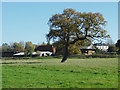
Upper Hammond's Farm
Looking across the field from the Long Walk towards the buildings of Upper Hammond's Farm on the edge of West Horsley.
Image: © Alan Hunt
Taken: 28 Oct 2014
0.07 miles
2
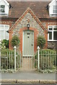
The Parish Room, West Horsley, Surrey
Now a private house, this building was originally the Village Reading Room (1867), then a dinner hall for the local school.
Image: © Peter Trimming
Taken: 17 Sep 2009
0.11 miles
3
The Parish Room, West Horsley, Surrey
Now a private house, this was originally the Village Reading Room (1867), then a dinning hall for the local school. The road running to the left of picture is School Lane.
Image: © Peter Trimming
Taken: 17 Sep 2009
0.11 miles
4
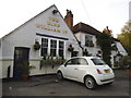
The King William IV, West Horsley, Surrey
Looks inviting, although the Gardener appears to have gone on holiday.
Image: © Peter Trimming
Taken: 17 Sep 2009
0.13 miles
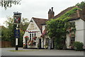
6
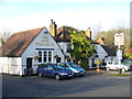
The King William IV
One of two historic village pubs on The Street, West Horsley.
Image: © Colin Smith
Taken: 10 Dec 2011
0.13 miles
7

Upper Hammond's Farm
viewed from Hatchlands Park
Image: © Paul Gillett
Taken: 28 Aug 2013
0.16 miles
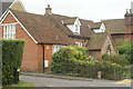
8
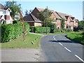
Houses in Ripley Lane, West Horsley
looking south-east
Image: © Andrew Longton
Taken: 8 Sep 2005
0.17 miles
9

Trees near Upper Hammond's Farm
at the NE corner of Hatchlands Park
Image: © Paul Gillett
Taken: 28 Aug 2013
0.20 miles
10
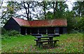
Picnic area and barn by Little Wix Wood
This is in the parkland at Hatchlands.
Image: © Shazz
Taken: 29 Oct 2014
0.21 miles