IMAGES TAKEN NEAR TO
Calvert Road, LEATHERHEAD, KT24 5SF
Introduction
This page details the photographs taken nearby to Calvert Road, KT24 5SF by members of the Geograph project.
The Geograph project started in 2005 with the aim of publishing, organising and preserving representative images for every square kilometre of Great Britain, Ireland and the Isle of Man.

There are currently over 7.5m images from over14,400 individuals and you can help contribute to the project by visiting https://www.geograph.org.uk
Image Map
Images are licensed for reuse under creativecommons.org/licenses/by-sa/2.0
Notes
- Clicking on the map will re-center to the selected point.
- The higher the marker number, the further away the image location is from the centre of the postcode.
Image Listing (10 Images Found)
Images are licensed for reuse under creativecommons.org/licenses/by-sa/2.0
Image
Details
Distance
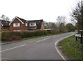
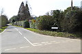
1
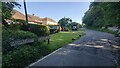
Calvert Road
New houses in a rural setting.
Image: © James Emmans
Taken: 16 Jul 2021
0.11 miles
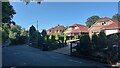
2
Calvert Road, Effingham
The conifers have been planted in the last few years.
Image: © David Howard
Taken: 6 Dec 2015
0.17 miles
4
Old London Lane
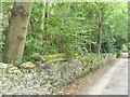
Former drove road passing between East Horsley and Effingham.
The crumbling flint wall with tiled capping on the left marks the eastern boundary of the old Lovelace estate.
Image: © Colin Smith
Taken: 23 Sep 2007
0.18 miles
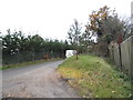
5
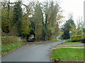
Junction of Dirtham Lane and Calvert Road
A bizarre junction. Dirtham Lane comes from behind the viewpoint and continues to the left as a track, but with full public road status. Branching right is Calvert Road, not a public road but owned by Guildford Borough Council. Dirtham Lane has a 30 limit, and the signs denote this, but unusually with no advice on this side, presumably because beyond is not a public highway. The track to the left continues with a 30 limit and repeater signs at intervals. The routes eventually reunite.
Image: © Robin Webster
Taken: 22 Nov 2011
0.20 miles
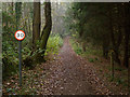
6
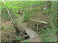
Footbridge in Parrott's Copse
Horsley Jubilee Trail passing through dense deciduous woodland. The trail gets its name from being completed in the Queen's Jubilee year, 2003.
Image: © Colin Smith
Taken: 23 Sep 2007
0.21 miles
9
30 limit on Dirtham Lane
A bizarre situation where this track has full public road status, and has a speed limit rather higher than most would attempt, not that there were any real signs of motor vehicles using it. The surface is better than many tracks, flint with no ruts or potholes, but it is very narrow.
Image: © Robin Webster
Taken: 22 Nov 2011
0.23 miles