IMAGES TAKEN NEAR TO
Guildford Road, LEATHERHEAD, KT24 5QL
Introduction
This page details the photographs taken nearby to Guildford Road, KT24 5QL by members of the Geograph project.
The Geograph project started in 2005 with the aim of publishing, organising and preserving representative images for every square kilometre of Great Britain, Ireland and the Isle of Man.

There are currently over 7.5m images from over14,400 individuals and you can help contribute to the project by visiting https://www.geograph.org.uk
Image Map
Images are licensed for reuse under creativecommons.org/licenses/by-sa/2.0
Notes
- Clicking on the map will re-center to the selected point.
- The higher the marker number, the further away the image location is from the centre of the postcode.
Image Listing (14 Images Found)
Images are licensed for reuse under creativecommons.org/licenses/by-sa/2.0
Image
Details
Distance
1
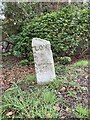
Turnpike milestone
Milestone on the former Leatherhead to Stoke (Guildford) turnpike, four miles out of Leatherhead.
Image: © Hugh Craddock
Taken: 23 Mar 2024
0.02 miles
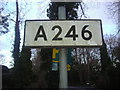
2
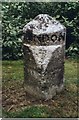
Old Milestone by the A246, Effingham
Carved stone post by the A246, in parish of EFFINGHAM (GUILDFORD District), Guildford end of Effingham village, between path and large hedge of house, on grass, on North side of road. Leatherhead cut stone, erected by the Leatherhead & Stoke next Guildford turnpike trust in the 19th century.
Inscription reads:- : LEATHERHEAD / 4½ : : LONDON / 23 : : GUILDFORD / 7 :
Carved benchmark and rivet on top.
Milestone Society National ID: SY_GULH07.
Image: © L Joseph
Taken: 22 Aug 2002
0.02 miles
3
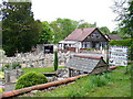
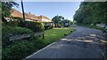
Tollgate Cottage
No sign of a former tollhouse is visible. The garden has a stock of ornamental statuary for sale. The sign says there are also eggs for sale.
Image: © Colin Smith
Taken: 19 May 2007
0.03 miles
4
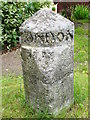
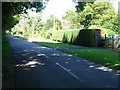
Milestone South-west of Effingham
On the Epsom Road, between Guildford and Leatherhead.
Image: © Colin Smith
Taken: 19 May 2007
0.03 miles
7
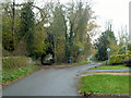
Junction of Dirtham Lane and Calvert Road
A bizarre junction. Dirtham Lane comes from behind the viewpoint and continues to the left as a track, but with full public road status. Branching right is Calvert Road, not a public road but owned by Guildford Borough Council. Dirtham Lane has a 30 limit, and the signs denote this, but unusually with no advice on this side, presumably because beyond is not a public highway. The track to the left continues with a 30 limit and repeater signs at intervals. The routes eventually reunite.
Image: © Robin Webster
Taken: 22 Nov 2011
0.19 miles
9
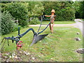
Bill (or is it Ben?)
Flower pot man with ornamental plough on grass verge outside country house on Salmons Road.
Image: © Colin Smith
Taken: 19 May 2007
0.22 miles
10
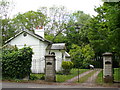
Lodge Gate near Effingham
Entrance to Effingham Lodge, south-west of the village. The gate has a metal arch with lamp.
Image: © Colin Smith
Taken: 19 May 2007
0.24 miles