IMAGES TAKEN NEAR TO
The Park, LEATHERHEAD, KT23 3LL
Introduction
This page details the photographs taken nearby to The Park, KT23 3LL by members of the Geograph project.
The Geograph project started in 2005 with the aim of publishing, organising and preserving representative images for every square kilometre of Great Britain, Ireland and the Isle of Man.

There are currently over 7.5m images from over14,400 individuals and you can help contribute to the project by visiting https://www.geograph.org.uk
Image Map
Images are licensed for reuse under creativecommons.org/licenses/by-sa/2.0
Notes
- Clicking on the map will re-center to the selected point.
- The higher the marker number, the further away the image location is from the centre of the postcode.
Image Listing (26 Images Found)
Images are licensed for reuse under creativecommons.org/licenses/by-sa/2.0
Image
Details
Distance
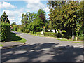
1
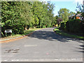
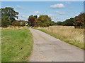
Elmfield, Fetcham
The junction of Elmfield, a residential cul-de-sac, with Meadow Way.
Image: © Alan Hunt
Taken: 20 Aug 2014
0.09 miles
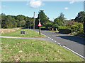
2
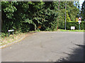
Squirrel Green
The corner at the junction of Squirrel Green and Meadow Way with the footpath to Bookham Common going off on the left.
Image: © Alan Hunt
Taken: 20 Aug 2014
0.12 miles
4
Eastwick Drive, Fetcham
A residential road developed during the 1950s and 60s on the land of the former Eastwick Park.
Image: © Alan Hunt
Taken: 20 Aug 2014
0.15 miles
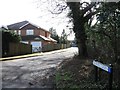
5
Church Road, Little Bookham
The road that runs past the church in the village centre to the common and the railway station.
Image: © Alan Hunt
Taken: 20 Aug 2014
0.15 miles
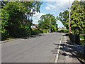
6
Meadow Way, Fetcham
The junction of Meadow Way with Eastwick Drive in this residential area of Fetcham.
Image: © Alan Hunt
Taken: 20 Aug 2014
0.15 miles
7
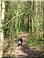
A Woodland Footpath from the Commons towards Great Bookham
Image: © Chris Reynolds
Taken: 22 Mar 2009
0.15 miles
8
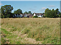
Bookham Common
The grass area running down Church Road. The white house beyond used to be a farm.
Image: © Alan Hunt
Taken: 20 Aug 2014
0.16 miles
9
Access road to Merrylands Farm
The access road off Church Road to Merrylands Farm, a residential cul-de-sac. The old maps have Merrylands Farm positioned further up Church Road near the corner by the station. This site used to be occupied by another farm.
Image: © Alan Hunt
Taken: 20 Aug 2014
0.16 miles
10
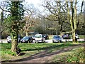
Car Park on Great Bookham Common
Bookham Commons http://en.wikipedia.org/wiki/Bookham_Commons are owned by the National Trust http://www.nationaltrust.org.uk/main/w-global/w-localtoyou/w-south_east/w-south_east-countryside/w-south_east-places-n and this is a convenient car park off Church Road, Great Bookham, with good access to the commons.
Image: © Chris Reynolds
Taken: 22 Mar 2009
0.16 miles