IMAGES TAKEN NEAR TO
Guildford Road, LEATHERHEAD, KT22 9DP
Introduction
This page details the photographs taken nearby to Guildford Road, KT22 9DP by members of the Geograph project.
The Geograph project started in 2005 with the aim of publishing, organising and preserving representative images for every square kilometre of Great Britain, Ireland and the Isle of Man.

There are currently over 7.5m images from over14,400 individuals and you can help contribute to the project by visiting https://www.geograph.org.uk
Image Map
Images are licensed for reuse under creativecommons.org/licenses/by-sa/2.0
Notes
- Clicking on the map will re-center to the selected point.
- The higher the marker number, the further away the image location is from the centre of the postcode.
Image Listing (10 Images Found)
Images are licensed for reuse under creativecommons.org/licenses/by-sa/2.0
Image
Details
Distance
1
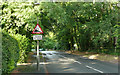
Hawk's Hill - Steep Hill 11%
Hawk's Hill, Leatherhead. 11% steep hill down sign.
Image: © Adam Morse
Taken: 6 Jul 2009
0.03 miles
2
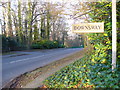
Looking Down Hawk's Hill
This is a main road running south-westwards from Leatherhead. It is lined by large detached exclusive houses, most of which are very secluded and hidden behind hedges and trees. They have obvious names, not numbers.
Image: © Colin Smith
Taken: 10 Feb 2008
0.08 miles
3
Hawk's Hill
The B2122 on the southern edge of Fetcham, leading down towards Leatherhead.
Image: © Ian Capper
Taken: 11 Jul 2019
0.10 miles
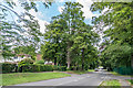
4
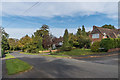
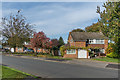
The Mount
Upmarket development of land previously forming part of the Fetcham Park estate, sold off by the owners, the Hankey family, in 1924 following the death of Captain Thomas Hankey.
Image: © Ian Capper
Taken: 30 Oct 2019
0.15 miles
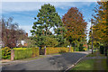
5
The Mount
Upmarket development of land previously forming part of the Fetcham Park estate, sold off by the owners, the Hankey family, in 1924 following the death of Captain Thomas Hankey.
Image: © Ian Capper
Taken: 30 Oct 2019
0.16 miles
6
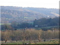
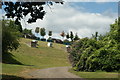
Vineyard on Hawk's Hill
Scrubby vineyard on south-facing slopes south-west of Leatherhead. The train in middle distance is heading through the Mole Gap to Dorking. In the background are the woody eastern slopes of the Mole Gap above Mickleham.
Image: © Colin Smith
Taken: 10 Feb 2008
0.17 miles
7
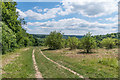
Thorncroft Elderflower Orchard
Elderflower orchard south of Leatherhead, used for the making of Thorncroft cordials.
Image: © Ian Capper
Taken: 11 Jul 2019
0.20 miles
8
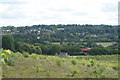
View From Hawk's Hill, Leatherhead, Surrey
The vines in the foreground are in this grid square. In the middle distance, a train scurries past and, in the distance, the outskirts of Leatherhead can be seen.
Image: © Peter Trimming
Taken: 10 Jul 2009
0.21 miles
9
Fetcham Park Drive
Road connecting The Mount with the Badingham Drive estate, a development that started in 1968 on the former playing fields of Badingham College. This school had been based in Fetcham Park for much of the period from 1927 until 1965 when it moved to Norfolk.
Image: © Ian Capper
Taken: 30 Oct 2019
0.22 miles
10
Reservoir, Leatherhead, Surrey
Under the steep slope is a covered reservoir.
Image: © Peter Trimming
Taken: 10 Jul 2009
0.25 miles