IMAGES TAKEN NEAR TO
Cobham Road, LEATHERHEAD, KT22 9AW
Introduction
This page details the photographs taken nearby to Cobham Road, KT22 9AW by members of the Geograph project.
The Geograph project started in 2005 with the aim of publishing, organising and preserving representative images for every square kilometre of Great Britain, Ireland and the Isle of Man.

There are currently over 7.5m images from over14,400 individuals and you can help contribute to the project by visiting https://www.geograph.org.uk
Image Map
Images are licensed for reuse under creativecommons.org/licenses/by-sa/2.0
Notes
- Clicking on the map will re-center to the selected point.
- The higher the marker number, the further away the image location is from the centre of the postcode.
Image Listing (109 Images Found)
Images are licensed for reuse under creativecommons.org/licenses/by-sa/2.0
Image
Details
Distance
1
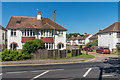
Cobham Road
1930s housing in Cobham Road and (beyond) Sunmead Close. Sunmead Close is named after a nearby house, Sunmead House, demolished in 1935.
Image: © Ian Capper
Taken: 26 May 2017
0.01 miles
2
2A Cobham Road
Very small house in Cobham Road.
Image: © Ian Capper
Taken: 26 May 2017
0.02 miles
3

Sunmead Close
1930s housing built on the land of Sunmead House, demolished in 1935.
Image: © Ian Capper
Taken: 11 Jul 2019
0.03 miles
4
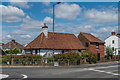
Zen Garden
Chinese restaurant at the junction of Cobham Road and Guildford Road. The building is a medieval hall house, dating originally from the 14th or 15th Century with subsequent additions and alterations, which from the 18th/19th Century to the 1930s housed a pub, The Rising Sun (later replaced by a pub of the same name on the opposite side of Cobham Road, after which this building as marked on maps as Ye Olde Rising Sun; later uses included a youth hostel). Grade II* listed - see www.historicengland.org.uk/listing/the-list/list-entry/1028662.
Image: © Ian Capper
Taken: 11 Jul 2019
0.03 miles
5
Zen Garden
Chinese restaurant at the junction of Cobham Road and Guildford Road. The building is a medieval hall house, dating originally from the 14th or 15th Century with subsequent additions and alterations, which from the 18th/19th Century to the 1930s housed a pub, The Rising Sun (later replaced by a pub of the same name on the opposite side of Cobham Road, after which this building as marked on maps as Ye Olde Rising Sun; later uses included a youth hostel). Grade II* listed - see www.historicengland.org.uk/listing/the-list/list-entry/1028662.
Image: © Ian Capper
Taken: 15 Aug 2019
0.03 miles
6
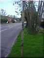
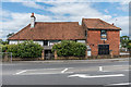
Emerging stripes on pole, Cobham Road
Surrey council painted many of its stripy poles grey in the 1960s and it is now beginning to wear off.
Image: © David Howard
Taken: 19 Apr 2009
0.03 miles
7
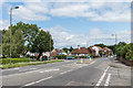
Guildford Road
The B2122 Guildford Road as it leaves Fetcham and enters Leatherhead. The roundabout is where it is met by Cobham Road. To the right of the lamppost on the left is the milestone in Image
Image: © Ian Capper
Taken: 15 Aug 2019
0.04 miles
8

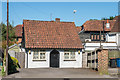
Harroway Manor
Sheltered housing built in 2006 on the corner of Hawk's Hill and Cobham Road on the site of the Rising Sun pub, which had stood here from the 1930s, replacing the former Rising Sun on the other side of Cobham Road (now the Zen Garden - see Image).
Image: © Ian Capper
Taken: 5 Sep 2019
0.04 miles
9
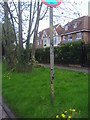
Emerging stripes on parking restriction pole
The second view of this pole, showing the buildings rather than the road. Before 1964 parking restriction poles had yellow stripes, and Surrey painted most striped poles with grey paint which is now coming off most of them.
Image: © David Howard
Taken: 19 Apr 2009
0.04 miles
10
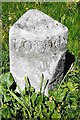
Old Milestone, B2122, Hawk's Hill, Fetcham
The milestone is located by Harraway Manor flats, on the North side of the road, on the grass verge. Parish of Leatherhead (Mole Valley District). Carved stone post, Leatherhead cut multi-faced design, erected by Leatherhead & Stoke next Guildford turnpike trust, 19th century.
Inscription reads:- LEATHERHEAD / ½ :: LONDON / 19 / SUTTON / 8 :: (GUILDFORD / 11 /) :: {Bell shape} LEATHERHEAD
Grade II listed by Historic England, List Entry Number: 1391539 https://historicengland.org.uk/listing/the-list/list-entry/1391539
Milestone Society National ID: SY_GULH11
Image: © Janet Dowding
Taken: 1 Apr 2009
0.04 miles