IMAGES TAKEN NEAR TO
Sunmead Close, LEATHERHEAD, KT22 9AP
Introduction
This page details the photographs taken nearby to Sunmead Close, KT22 9AP by members of the Geograph project.
The Geograph project started in 2005 with the aim of publishing, organising and preserving representative images for every square kilometre of Great Britain, Ireland and the Isle of Man.

There are currently over 7.5m images from over14,400 individuals and you can help contribute to the project by visiting https://www.geograph.org.uk
Image Map
Images are licensed for reuse under creativecommons.org/licenses/by-sa/2.0
Notes
- Clicking on the map will re-center to the selected point.
- The higher the marker number, the further away the image location is from the centre of the postcode.
Image Listing (153 Images Found)
Images are licensed for reuse under creativecommons.org/licenses/by-sa/2.0
Image
Details
Distance
1
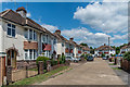
Sunmead Close
1930s housing built on the land of Sunmead House, demolished in 1935.
Image: © Ian Capper
Taken: 11 Jul 2019
0.01 miles
2
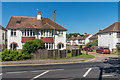
Cobham Road
1930s housing in Cobham Road and (beyond) Sunmead Close. Sunmead Close is named after a nearby house, Sunmead House, demolished in 1935.
Image: © Ian Capper
Taken: 26 May 2017
0.04 miles
3
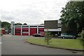
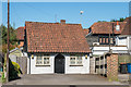
Leatherhead fire station
Leatherhead fire station, Cobham Road, Leatherhead, Surrey
Image: © Kevin Hale
Taken: 17 Jun 2007
0.05 miles
4
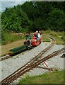
Miniature Railway
Operated by the Surrey Society of Model Engineers
Image: © Martyn Davies
Taken: 28 Jun 2009
0.05 miles
5
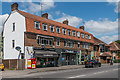
Sunmead Parade
1930s shopping parade built on the land of Sunmead House, demolished in 1935.
Image: © Ian Capper
Taken: 11 Jul 2019
0.05 miles
6
2A Cobham Road
Very small house in Cobham Road.
Image: © Ian Capper
Taken: 26 May 2017
0.05 miles
7
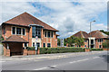
Juniper House and United Technologies House
Office buildings (Juniper House is the nearer one) on Guildford Road, built at the start of the 21st Century on the site of Leatherhead Bus Garage which had stood here from 1924 until closure in 1999. In the background can be seen the drill tower of Leatherhead Fire Station.
Image: © Ian Capper
Taken: 15 Aug 2019
0.06 miles
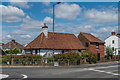
8
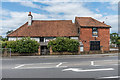
Zen Garden
Chinese restaurant at the junction of Cobham Road and Guildford Road. The building is a medieval hall house, dating originally from the 14th or 15th Century with subsequent additions and alterations, which from the 18th/19th Century to the 1930s housed a pub, The Rising Sun (later replaced by a pub of the same name on the opposite side of Cobham Road, after which this building as marked on maps as Ye Olde Rising Sun; later uses included a youth hostel). Grade II* listed - see www.historicengland.org.uk/listing/the-list/list-entry/1028662.
Image: © Ian Capper
Taken: 15 Aug 2019
0.06 miles
9
Zen Garden
Chinese restaurant at the junction of Cobham Road and Guildford Road. The building is a medieval hall house, dating originally from the 14th or 15th Century with subsequent additions and alterations, which from the 18th/19th Century to the 1930s housed a pub, The Rising Sun (later replaced by a pub of the same name on the opposite side of Cobham Road, after which this building as marked on maps as Ye Olde Rising Sun; later uses included a youth hostel). Grade II* listed - see www.historicengland.org.uk/listing/the-list/list-entry/1028662.
Image: © Ian Capper
Taken: 11 Jul 2019
0.06 miles
10
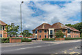
United Technologies House
Office building on Guildford Road, built at the start of the 21st Century on the site of Leatherhead Bus Garage which had stood here from 1924 until closure in 1999. In the background can be seen the Leatherhead Fire Station.
Image: © Ian Capper
Taken: 15 Aug 2019
0.06 miles