IMAGES TAKEN NEAR TO
Guildford Road, LEATHERHEAD, KT22 9AD
Introduction
This page details the photographs taken nearby to Guildford Road, KT22 9AD by members of the Geograph project.
The Geograph project started in 2005 with the aim of publishing, organising and preserving representative images for every square kilometre of Great Britain, Ireland and the Isle of Man.

There are currently over 7.5m images from over14,400 individuals and you can help contribute to the project by visiting https://www.geograph.org.uk
Image Map
Images are licensed for reuse under creativecommons.org/licenses/by-sa/2.0
Notes
- Clicking on the map will re-center to the selected point.
- The higher the marker number, the further away the image location is from the centre of the postcode.
Image Listing (383 Images Found)
Images are licensed for reuse under creativecommons.org/licenses/by-sa/2.0
Image
Details
Distance
1

Riverbridge House
Serviced office building on Guildford Road, built around 2007 on a former Seeboard electricity company depot.
Image: © Ian Capper
Taken: 7 Aug 2019
0.01 miles
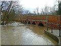
2

River Mole in flood
High water levels on the River Mole, seen from Leatherhead Bridge.
Image: © Ian Capper
Taken: 21 Dec 2019
0.02 miles
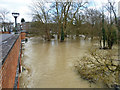
3

Guildford Road - flooding
Flooding on Guildford Road near its junction with Waterway Road, seen in the background. This had arisen from high water levels on the River Mole after a period of heavy rain brought by Storm Dennis, falling on ground already saturated from Storm Ciara a week earlier. Some vehicles were able to make it through the flood, but not the Mercedes stranded near the junction.
Image: © Ian Capper
Taken: 17 Feb 2020
0.02 miles
4

Grove House
Office block built in the grounds of what was until 1998, the site of a large house called Fetcham Grove, originally dating from at least the 18th Century. Originally a private house, for many years this had been occupied by the intriguingly named Green Domino Hotel & Restaurant until closure in the 1940s, after which it was used by a removals firm as a depository.
Image: © Ian Capper
Taken: 11 Jul 2019
0.03 miles
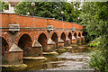
5

Leatherhead Bridge
Leatherhead Bridge (or Town Bridge) over the River Mole has medieval origins and was rebuilt and enlarged in the 1780s. Grade II listed - see www.historicengland.org.uk/listing/the-list/list-entry/1028646.
Image: © Ian Capper
Taken: 17 Apr 2019
0.03 miles
6
Leatherhead Bridge
The River Mole is much higher than usual and the waterside paths are flooded. The fourteen arch bridge is a grade II listed building, dated 1784, thought to be a rebuild of an earlier bridge.
Image: © Robin Webster
Taken: 15 Feb 2014
0.03 miles
7

Leatherhead Bridge
Leatherhead Bridge (or Town Bridge) over the River Mole has medieval origins and was rebuilt and enlarged in the 1780s. Grade II listed - see www.historicengland.org.uk/listing/the-list/list-entry/1028646. Seen here with the river in flood after a period of heavy rain brought by Storm Dennis, falling on ground already saturated from Storm Ciara a week earlier - compare Image for more normal conditions, with water level data suggesting a difference between the two dates of over 2.2m.
Image: © Ian Capper
Taken: 17 Feb 2020
0.03 miles
8
River Mole in flood, Leatherhead
The upstream side of Leatherhead Bridge. Normally there are islands here on which the trees grow.
Image: © Robin Webster
Taken: 15 Feb 2014
0.03 miles
9

The River Mole at Leatherhead, looking upstream towards Town Bridge
There are four bridges across the Mole within this grid-square. Town Bridge is the furthest upstream, and is the oldest of the four, dating from the 18th century in its present form.
Image: © Stefan Czapski
Taken: 10 Jan 2012
0.03 miles
10
Leatherhead Bridge
Leatherhead Bridge (or Town Bridge) over the River Mole has medieval origins and was rebuilt and enlarged in the 1780s. Grade II listed - see www.historicengland.org.uk/listing/the-list/list-entry/1028646. Low water levels revealed what would appear to be a line of stepping stones, although I have found no reference to them elsewhere.
Image: © Ian Capper
Taken: 8 Aug 2019
0.03 miles