IMAGES TAKEN NEAR TO
Ermyn Way, LEATHERHEAD, KT22 8UY
Introduction
This page details the photographs taken nearby to Ermyn Way, KT22 8UY by members of the Geograph project.
The Geograph project started in 2005 with the aim of publishing, organising and preserving representative images for every square kilometre of Great Britain, Ireland and the Isle of Man.

There are currently over 7.5m images from over14,400 individuals and you can help contribute to the project by visiting https://www.geograph.org.uk
Image Map
Images are licensed for reuse under creativecommons.org/licenses/by-sa/2.0
Notes
- Clicking on the map will re-center to the selected point.
- The higher the marker number, the further away the image location is from the centre of the postcode.
Image Listing (12 Images Found)
Images are licensed for reuse under creativecommons.org/licenses/by-sa/2.0
Image
Details
Distance
1
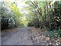
Track at the end of Ermyn Way, Ashtead
Image: © David Howard
Taken: 16 Nov 2014
0.11 miles
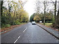
2
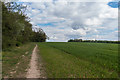
Field edge
Field edge alongside Ermyn Way.
Image: © Ian Capper
Taken: 28 Apr 2017
0.13 miles
3
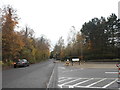
Ermyn Way, Ashtead
At the entrance to Exxonmobil House, which I think used to be a plastic factory before they built their new offices around the 90s.
Image: © David Howard
Taken: 16 Nov 2014
0.14 miles
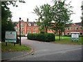
4
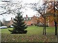
Milner House, Ashtead
The Ex-Services Welfare Society building is now a care home. This is the view from above http://www.britainfromabove.org.uk/image/EPW032795
Image: © David Howard
Taken: 16 Nov 2014
0.15 miles
5
Milner House
looking north-east from Ermyn Way
Image: © Andrew Longton
Taken: 4 Oct 2005
0.17 miles
6
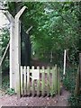
No way out
A permissive path that doesn't go anywhere!
Image: © don cload
Taken: 12 Sep 2012
0.18 miles
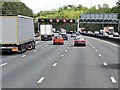
8
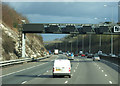
M25 near Leatherhead
Heading east (anticlockwise).
Image: © JThomas
Taken: 5 Mar 2012
0.24 miles
10
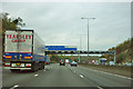
M25 - 1/2 mile to junction 9
Ahead is the junction for the A243 and A24.
Image: © Robin Webster
Taken: 9 Nov 2011
0.25 miles