IMAGES TAKEN NEAR TO
Epsom Road, LEATHERHEAD, KT22 8TQ
Introduction
This page details the photographs taken nearby to Epsom Road, KT22 8TQ by members of the Geograph project.
The Geograph project started in 2005 with the aim of publishing, organising and preserving representative images for every square kilometre of Great Britain, Ireland and the Isle of Man.

There are currently over 7.5m images from over14,400 individuals and you can help contribute to the project by visiting https://www.geograph.org.uk
Image Map
Images are licensed for reuse under creativecommons.org/licenses/by-sa/2.0
Notes
- Clicking on the map will re-center to the selected point.
- The higher the marker number, the further away the image location is from the centre of the postcode.
Image Listing (89 Images Found)
Images are licensed for reuse under creativecommons.org/licenses/by-sa/2.0
Image
Details
Distance
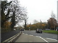
1
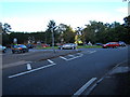
Roundabout at the junction of the A24 (right and foreground), A243 (ahead) and B2122 (left).
Image: © Roger Miller
Taken: 2 Oct 2005
0.03 miles
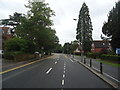
3
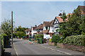
Daymerslea Ridge
Cul de sac off Epsom Road, developed in the c1950s.
Image: © Ian Capper
Taken: 15 May 2019
0.05 miles
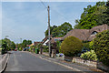
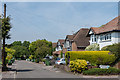
5
Homelands
Cul de sac off Epsom Road, developed in the 1930s.
Image: © Ian Capper
Taken: 15 May 2019
0.07 miles
6
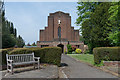
Christ Church URC
United Reformed Church (previously Congregational before their merger with the Presbyterians in 1972). Dedicated on 1 May 1935, it replaced an earlier building in North Street dating from the 1840s.
Image: © Ian Capper
Taken: 15 May 2019
0.07 miles
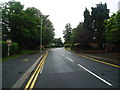
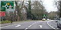
7
The Knoll Roundabout, Leatherhead
For anyone going to use the Leatherhead Bypass the entire left lane of the two is for the left turn only, so get in the middle quickly after the M25 intersection if you're going straight ahead as it's not made obvious.
Image: © David Howard
Taken: 16 Nov 2014
0.08 miles

10
Melvinshaw
Cul de sac off Epsom Road, developed in the c1950s on the grounds of a house marked on the 1934-8 1:10,560 map as "Melvin".
Image: © Ian Capper
Taken: 15 May 2019
0.08 miles