IMAGES TAKEN NEAR TO
Fortyfoot Road, LEATHERHEAD, KT22 8RP
Introduction
This page details the photographs taken nearby to Fortyfoot Road, KT22 8RP by members of the Geograph project.
The Geograph project started in 2005 with the aim of publishing, organising and preserving representative images for every square kilometre of Great Britain, Ireland and the Isle of Man.

There are currently over 7.5m images from over14,400 individuals and you can help contribute to the project by visiting https://www.geograph.org.uk
Image Map
Images are licensed for reuse under creativecommons.org/licenses/by-sa/2.0
Notes
- Clicking on the map will re-center to the selected point.
- The higher the marker number, the further away the image location is from the centre of the postcode.
Image Listing (85 Images Found)
Images are licensed for reuse under creativecommons.org/licenses/by-sa/2.0
Image
Details
Distance
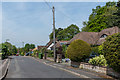
1
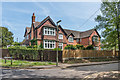
Homefield
Late Victorian house on Fortyfoot Road, marked on older maps variously as Holmefield and Homefields. It is now divided into retirement flats managed by Leatherhead United Charities.
Image: © Ian Capper
Taken: 15 May 2019
0.01 miles
2
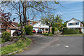
Homefield Close
1960s cul de sac off Fortyfoot Road developed in the grounds of Homefield (see Image). The footpath between the two houses leads to Daymerslea Ridge.
Image: © Ian Capper
Taken: 15 May 2019
0.02 miles
3
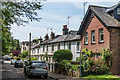
Poplar Road
Late 19th Century housing in Poplar Road.
Image: © Ian Capper
Taken: 15 May 2019
0.07 miles
4
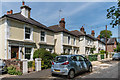
Poplar Road
Late 19th Century villas in Poplar Road.
Image: © Ian Capper
Taken: 15 May 2019
0.08 miles
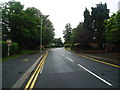
5
Daymerslea Ridge
Cul de sac off Epsom Road, developed in the c1950s.
Image: © Ian Capper
Taken: 15 May 2019
0.09 miles
6

Leatherhead Hospital
Community hospital off Poplar Road which opened in May 1940, built on land donated by C F Leach of Vale Lodge.
Image: © Ian Capper
Taken: 15 May 2019
0.10 miles
7

St John's Road
Victorian housing on St John's Road, seen from its junction with Poplar Road. In the background is part of St John's School.
Image: © Ian Capper
Taken: 15 May 2019
0.11 miles
8

St John's Road
Victorian housing on St John's Road. In the background is part of St John's School.
Image: © Ian Capper
Taken: 15 May 2019
0.12 miles
10
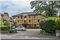
Fircroft
Flats in Epsom Road, completed in 1995 on the site of a late 19th Century house of the same name.
Image: © Ian Capper
Taken: 6 Aug 2019
0.12 miles