IMAGES TAKEN NEAR TO
Church Road, LEATHERHEAD, KT22 8AY
Introduction
This page details the photographs taken nearby to Church Road, KT22 8AY by members of the Geograph project.
The Geograph project started in 2005 with the aim of publishing, organising and preserving representative images for every square kilometre of Great Britain, Ireland and the Isle of Man.

There are currently over 7.5m images from over14,400 individuals and you can help contribute to the project by visiting https://www.geograph.org.uk
Image Map
Images are licensed for reuse under creativecommons.org/licenses/by-sa/2.0
Notes
- Clicking on the map will re-center to the selected point.
- The higher the marker number, the further away the image location is from the centre of the postcode.
Image Listing (467 Images Found)
Images are licensed for reuse under creativecommons.org/licenses/by-sa/2.0
Image
Details
Distance
1
Leatherhead Methodist Church
Methodist church in Church Road, built in 1893, replacing a "tin tabernacle" erected on the site in 1887, which was retained as the sunday school until replaced by the school room added in 1905 (seen in the centre of the photo) and in the background is the manse.
Image: © Ian Capper
Taken: 30 Apr 2019
0.00 miles
2
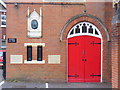
Wesleyan Chapel, Leatherhead
One of two churches on Church Road which leads to Leatherhead's parish church. The plaque here says that Wesley preached his last sermon in Leatherhead here.
http://www.visitleatherhead.com/
Image: © Colin Smith
Taken: 29 May 2011
0.01 miles
3
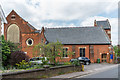
Leatherhead Methodist Church
Methodist church in Church Road, built in 1893, replacing a "tin tablernacle" erected on the site in 1887, which was retained as the sunday school until replaced by the school room added in 1905 (seen on the left of the photo)
Image: © Ian Capper
Taken: 30 Apr 2019
0.01 miles
4
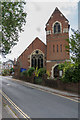
Leatherhead Methodist Church
Methodist church in Church Road, built in 1893, replacing a "tin tablernacle" erected on the site in 1887, which was retained as the sunday school until replaced by the school room added in 1905.
Image: © Ian Capper
Taken: 30 Apr 2019
0.01 miles
5
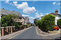
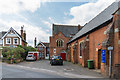
Church Road
Looking along Church Road. In the background is Leatherhead Methodist Church - see Image
Image: © Ian Capper
Taken: 16 Jul 2019
0.01 miles
6

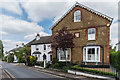
29 Church Road
Edwardian house in Church Road.
Image: © Ian Capper
Taken: 15 Aug 2019
0.02 miles
7
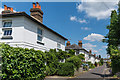
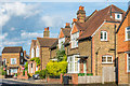
15 - 21 Church Road
Late 19th Century houses in Church Road. The shield on nos 19 - 21, nearest the camera, says "Myrtle Cottages", with a date of 187? (the last digit being indistinct).
Image: © Ian Capper
Taken: 30 Apr 2019
0.04 miles
8
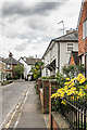
Waverley Place
Short road connecting The Crescent and Church Road (in the background - originally Magazine Lane), dating from the late 19th Century.
Image: © Ian Capper
Taken: 2 May 2019
0.04 miles
9
Magazine Place
Cul-de-sac of late Victorian semi-detached villas off Church Road. The name is thought to derive from the storage of ammunition in the area during the 7 Years' War.
Image: © Ian Capper
Taken: 16 Jul 2019
0.04 miles
10
14 - 16 and 18 - 20 The Crescent
19th Century buildings in The Crescent.
Image: © Ian Capper
Taken: 31 Jul 2019
0.04 miles