IMAGES TAKEN NEAR TO
Highbury Drive, LEATHERHEAD, KT22 7UN
Introduction
This page details the photographs taken nearby to Highbury Drive, KT22 7UN by members of the Geograph project.
The Geograph project started in 2005 with the aim of publishing, organising and preserving representative images for every square kilometre of Great Britain, Ireland and the Isle of Man.

There are currently over 7.5m images from over14,400 individuals and you can help contribute to the project by visiting https://www.geograph.org.uk
Image Map
Images are licensed for reuse under creativecommons.org/licenses/by-sa/2.0
Notes
- Clicking on the map will re-center to the selected point.
- The higher the marker number, the further away the image location is from the centre of the postcode.
Image Listing (135 Images Found)
Images are licensed for reuse under creativecommons.org/licenses/by-sa/2.0
Image
Details
Distance
1
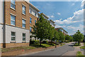
Highbury Drive
Development completed in 2006/7 off Randalls Way on the site of the laboratories of the Printing Industry Research Association, Patra House built in 1963 with its extension added in 1971. On the left is Burney House, with Sheridan House beyond.
Image: © Ian Capper
Taken: 16 May 2019
0.02 miles
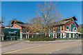
2

Federation House, Leatherhead
Federation House is an award-winning conference and meetings venue and full service hotel with 55 air-conditioned bedrooms and a large open atrium area with restaurant and bar. It also acts as headquarters for the Police Federation of England and Wales, the staff association for rank and file police officers.
Image: © Ann
Taken: 5 Aug 2018
0.04 miles
3

Police Force badges of England and Wales, Leatherhead
Federation House is an award-winning conference and meetings venue and full service hotel with 55 air-conditioned bedrooms and a large open atrium area with restaurant and bar. It also acts as headquarters for the Police Federation of England and Wales, the staff association for rank and file police officers.
Image: © Ann
Taken: 5 Aug 2018
0.04 miles
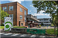
4
Federation House
Looking across Randalls Road to the Police Federation's Federation House.
Image: © Ian Capper
Taken: 20 Nov 2019
0.05 miles
5
Former Leatherhead Food Research Laboratories
Research laboratories in Randalls Way, built in 1950 for the Leatherhead Food Research Laboratories with a subsequent extension beyond. The premises are now empty, the work having moved to Great Burgh, near Banstead.
Image: © Ian Capper
Taken: 16 May 2019
0.05 miles
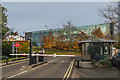
6
Wates House
Office building on Station Approach, built in the 1990s for the IT firm Logica and then headquarters of the Wates building firm since around 2002. The development originally consisted of two buildings, Babbage House and Tirian House (seen here), which were linked by the glass structure on the left of the photo around 2003.
On the far right of the photo can be seen the sculpture "The Leopard" by Jonathan Kenworthy see Image and Image
Image: © Ian Capper
Taken: 10 Apr 2019
0.08 miles
7
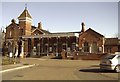
Leatherhead railway station
This is the main entrance, viewed from the west. The line goes north to Epsom, south to Guildford or the South Coast.
Image: © graham ross
Taken: 25 Feb 2006
0.08 miles
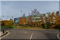
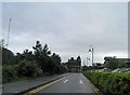
8
Ronson Way
Barriers at the end of Ronson Way, an access road off Randalls Road into Mole Business Park, built on the site of the factory of Ronson, manufacturer of cigarette lighters, which was situated here from 1953 to 1981. In the background is the Police Federation's Federation House, on the opposite side of Randalls Road.
Image: © Ian Capper
Taken: 20 Nov 2019
0.08 miles
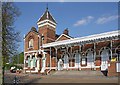
10
Leatherhead railway station from the car park
Image: © Steve Fareham
Taken: 12 Jun 2012
0.09 miles