IMAGES TAKEN NEAR TO
Kingston Road, LEATHERHEAD, KT22 7QF
Introduction
This page details the photographs taken nearby to Kingston Road, KT22 7QF by members of the Geograph project.
The Geograph project started in 2005 with the aim of publishing, organising and preserving representative images for every square kilometre of Great Britain, Ireland and the Isle of Man.

There are currently over 7.5m images from over14,400 individuals and you can help contribute to the project by visiting https://www.geograph.org.uk
Image Map
Images are licensed for reuse under creativecommons.org/licenses/by-sa/2.0
Notes
- Clicking on the map will re-center to the selected point.
- The higher the marker number, the further away the image location is from the centre of the postcode.
Image Listing (75 Images Found)
Images are licensed for reuse under creativecommons.org/licenses/by-sa/2.0
Image
Details
Distance
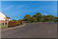
1
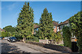
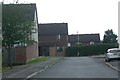
Ryebridge Close
Post Second World War maisonettes east of Kingston Road.
Image: © Ian Capper
Taken: 13 Sep 2019
0.02 miles
2
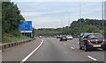
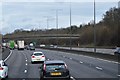
M25 Motorway sign
23 miles to Heathrow Airport.
At marker 63.3
Image: © Julian P Guffogg
Taken: 7 Aug 2013
0.04 miles
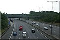
6
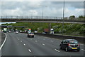
Teazlewood Park
Housing has inevitably encroached right up to the edge of the motorway here in Leatherhead.
Image: © Ben Gamble
Taken: 9 Jul 2005
0.06 miles
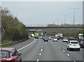
7
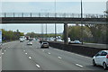
M25, J9
Taken from the footbridge over the M25 at junction 9 anti-clockwise. The junction for the clockwise carriageway is about a mile away!
Image: © Ben Gamble
Taken: 9 Jul 2005
0.06 miles
9

M25 to the West
The places listed are not greatly west and certainly not in The West. There must be an 'also' to be understood after 'The West'.
Image: © Robin Webster
Taken: 9 Nov 2011
0.07 miles
10
Kingston Road
A section of Kingston Road, truncated when the M25 was built here in the 1980s, in a cutting behind the fence in the background. On the left is Teazlewood Park, built on part of the Leatherhead Golf Course cut off by the building of the motorway.
Image: © Ian Capper
Taken: 13 Sep 2019
0.07 miles