IMAGES TAKEN NEAR TO
Queen Annes Gardens, LEATHERHEAD, KT22 7JE
Introduction
This page details the photographs taken nearby to Queen Annes Gardens, KT22 7JE by members of the Geograph project.
The Geograph project started in 2005 with the aim of publishing, organising and preserving representative images for every square kilometre of Great Britain, Ireland and the Isle of Man.

There are currently over 7.5m images from over14,400 individuals and you can help contribute to the project by visiting https://www.geograph.org.uk
Image Map (Loading...)


Getting Data...Please wait
Leaflet Map data © OpenStreetMap
Images are licensed for reuse under creativecommons.org/licenses/by-sa/2.0
Notes
- Clicking on the map will re-center to the selected point.
- The higher the marker number, the further away the image location is from the centre of the postcode.
Image Listing (385 Images Found)
Images are licensed for reuse under creativecommons.org/licenses/by-sa/2.0
Image
Details
Distance
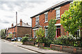
1
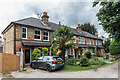
Queen Anne's Gardens
Early 20th Century terrace in a road off in Linden Road. A date plaque in the centre of the terrace gives a building year of 1903.
Image: © Ian Capper
Taken: 6 Aug 2019
0.01 miles
2
Queen Anne's Gardens
Early 20th Century terrace in a road off in Linden Road. The date plaque in the centre of the terrace gives a building year of 1903.
Image: © Ian Capper
Taken: 6 Aug 2019
0.02 miles
3
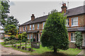
12 - 16 Fairfield Road
Housing in Fairfield Road. Nos 14 - 16 date from the late 19th Century, whereas no 12 dates from the 1980s, built on part of the site of further similar 19th Century pairs, demolished when Leret Way was built in the 1970s.
Image: © Ian Capper
Taken: 20 Nov 2019
0.02 miles
4
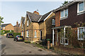
Fairfield Road
Road off Leret Way. It originally extended south of here, until the building of Leret Way in the 1970s and of the Swan Centre in the early 1980s. Nos 5 - 7 Fairfiled Road were once part of a terrace shown on the 1869 1:2,500 map, part demolished when Leret Way was built.
Image: © Ian Capper
Taken: 20 Nov 2019
0.02 miles
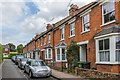
5
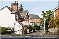
Linden Road
Turn of the 19th/20th Century houses in Linden Road.
Image: © Ian Capper
Taken: 6 Aug 2019
0.03 miles
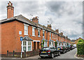
6
Queen Anne's Terrace
Late Victorian terrace in a road off in Linden Road. A date plaque at the far end of the terrace gives a building year of 1894.
Image: © Ian Capper
Taken: 6 Aug 2019
0.03 miles
7
17 - 23 Fairfield Road
Short terrace in Fairfield Road, which planning permission details suggest was built in the 1980s as "elderly people's flats".
Image: © Ian Capper
Taken: 20 Nov 2019
0.03 miles
8
Queen Anne's Terrace
Late Victorian terrace in a road off in Linden Road. The date plaque on the corner gives a building year of 1894.
Image: © Ian Capper
Taken: 6 Aug 2019
0.03 miles
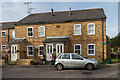
9
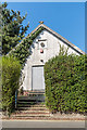
Hall, Queen Anne's Terrace
A corrugated iron hall attached to Leatherhead Constitutional Club, a social club situated on the corner of Linden Road and Queen Anne's Terrace (see Image).
Image: © Ian Capper
Taken: 10 Apr 2019
0.04 miles
10
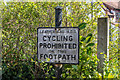
No cycling
Leatherhead Urban District Council "no cycling" sign at the entrance to Linden Pit Path - see Image for wider view.
Image: © Ian Capper
Taken: 10 Apr 2019
0.04 miles