IMAGES TAKEN NEAR TO
Tudor Walk, LEATHERHEAD, KT22 7HX
Introduction
This page details the photographs taken nearby to Tudor Walk, KT22 7HX by members of the Geograph project.
The Geograph project started in 2005 with the aim of publishing, organising and preserving representative images for every square kilometre of Great Britain, Ireland and the Isle of Man.

There are currently over 7.5m images from over14,400 individuals and you can help contribute to the project by visiting https://www.geograph.org.uk
Image Map
Images are licensed for reuse under creativecommons.org/licenses/by-sa/2.0
Notes
- Clicking on the map will re-center to the selected point.
- The higher the marker number, the further away the image location is from the centre of the postcode.
Image Listing (99 Images Found)
Images are licensed for reuse under creativecommons.org/licenses/by-sa/2.0
Image
Details
Distance
1
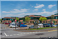
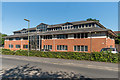
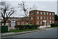
Randalls Research Park
Business park on Randalls Way. From left to right are Medina House, Cassini Court and Pascal Place.
Image: © Ian Capper
Taken: 16 May 2019
0.05 miles
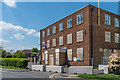
2
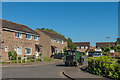
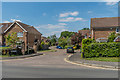
Tudor Walk
1970s/1980s housing off Cleeve Road.
Image: © Ian Capper
Taken: 26 May 2017
0.05 miles
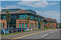
3
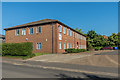
Fountain House
Office block on Cleeve Road, housing a number of businesses and other organisations.
Image: © Ian Capper
Taken: 26 May 2017
0.06 miles
4
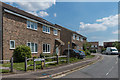
Tudor Walk
c.1980s housing off Cleeve Road, built on former playing fields.
Image: © Ian Capper
Taken: 16 May 2019
0.06 miles
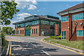
5
Cleeve Court
Office block on Cleeve Road, housing a number of businesses and other organisations.
Image: © Ian Capper
Taken: 26 May 2017
0.07 miles
6
Pascal Place and Belgravia House
Business units on Randalls Way.
Image: © Ian Capper
Taken: 16 May 2019
0.08 miles
7
Pascal Place and Belgravia House
Business units on Randalls Way.
Image: © Ian Capper
Taken: 16 May 2019
0.08 miles
8
Former Intertek House
Disused premises in Cleeve Road.
Image: © Ian Capper
Taken: 16 May 2019
0.09 miles
9
Leatherhead
Commercial site, awaiting redevelopment.
Image: © Peter Trimming
Taken: 21 Dec 2021
0.09 miles
10
Falcon Wood
Cul de sac off Cleeve Road, dating from 1997-8, built on the site of Randalls Park Farm.
Image: © Ian Capper
Taken: 16 May 2019
0.09 miles