IMAGES TAKEN NEAR TO
Boleyn Walk, LEATHERHEAD, KT22 7HU
Introduction
This page details the photographs taken nearby to Boleyn Walk, KT22 7HU by members of the Geograph project.
The Geograph project started in 2005 with the aim of publishing, organising and preserving representative images for every square kilometre of Great Britain, Ireland and the Isle of Man.

There are currently over 7.5m images from over14,400 individuals and you can help contribute to the project by visiting https://www.geograph.org.uk
Image Map
Images are licensed for reuse under creativecommons.org/licenses/by-sa/2.0
Notes
- Clicking on the map will re-center to the selected point.
- The higher the marker number, the further away the image location is from the centre of the postcode.
Image Listing (103 Images Found)
Images are licensed for reuse under creativecommons.org/licenses/by-sa/2.0
Image
Details
Distance
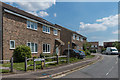
4
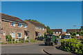
Tudor Walk
1970s/1980s housing off Cleeve Road.
Image: © Ian Capper
Taken: 26 May 2017
0.07 miles
5
Former Leatherhead Food Research Laboratories
Research laboratories in Randalls Way, built in 1950 for the Leatherhead Food Research Laboratories with a subsequent extension beyond. The premises are now empty, the work having moved to Great Burgh, near Banstead.
Image: © Ian Capper
Taken: 16 May 2019
0.08 miles
6
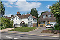
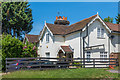
Farm Cottages and Springwood
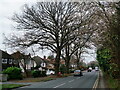
Houses on Randalls Road by its junction with Cleeve Road. Farm Cottages, on the left, are shown on the 1869 1:2,500 map when Randalls Road was called Randalls Lane and Cleeve Road was the access route to Randalls Farm (later Randalls Park Farm) where the 1997-8 built cul de sac Falcon Wood now stands (see Image).
Image: © Ian Capper
Taken: 16 May 2019
0.08 miles
7
Tudor Walk
c.1980s housing off Cleeve Road, built on former playing fields.
Image: © Ian Capper
Taken: 16 May 2019
0.08 miles
8
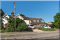
Farm Cottages and Springwood
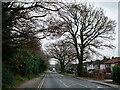
Contrasting housing in Randalls Road. Farm Cottages, on the left, are shown on the 1869 1:2500 map, associated with nearby Randalls Farm, whereas Springwood, on the right, wasn't built until around the 1980s, part of a development on the site of a former allotment gardens and playing fields.
Image: © Ian Capper
Taken: 26 May 2017
0.08 miles
9
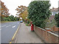
Farm Cottages
Houses on Randalls Road by its junction with Cleeve Road, shown on the 1869 1:2,500 map when Randalls Road was called Randalls Lane and Cleeve Road was the access route to Randalls Farm (later Randalls Park Farm) where the 1997-8 built cul de sac Falcon Wood now stands (see Image).
Image: © Ian Capper
Taken: 4 Jul 2019
0.08 miles
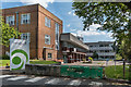
10
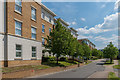
Highbury Drive
Development completed in 2006/7 off Randalls Way on the site of the laboratories of the Printing Industry Research Association, Patra House built in 1963 with its extension added in 1971. On the left is Burney House, with Sheridan House beyond.
Image: © Ian Capper
Taken: 16 May 2019
0.09 miles