IMAGES TAKEN NEAR TO
Upper Fairfield Road, LEATHERHEAD, KT22 7HH
Introduction
This page details the photographs taken nearby to Upper Fairfield Road, KT22 7HH by members of the Geograph project.
The Geograph project started in 2005 with the aim of publishing, organising and preserving representative images for every square kilometre of Great Britain, Ireland and the Isle of Man.

There are currently over 7.5m images from over14,400 individuals and you can help contribute to the project by visiting https://www.geograph.org.uk
Image Map (Loading...)


Getting Data...Please wait
Leaflet Map data © OpenStreetMap
Images are licensed for reuse under creativecommons.org/licenses/by-sa/2.0
Notes
- Clicking on the map will re-center to the selected point.
- The higher the marker number, the further away the image location is from the centre of the postcode.
Image Listing (409 Images Found)
Images are licensed for reuse under creativecommons.org/licenses/by-sa/2.0
Image
Details
Distance
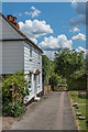
1
36 - 38 Upper Fairfield Road
Weatherboarded building in Upper Fairfield Road, which maps suggest dated originally from the mid 19th Century or earlier.
Image: © Ian Capper
Taken: 7 Aug 2019
0.00 miles
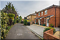
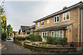
2
28 - 30 Middle Road
Pair of semi-detached houses in Middle Road.
Image: © Ian Capper
Taken: 6 Jun 2019
0.02 miles
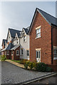
3
Fairfield House
2017 rebuild of a late 19th Century building on the corner of Fairfield Road and Upper Fairfield Road. The previous building was a social club, itself formed out of a large Victorian house of the same name (which maps suggest dated originally from the mid 19th Century or earlier). Photos and planning documents suggest that the present building largely mimics the design of the original.
Image: © Ian Capper
Taken: 7 Aug 2019
0.02 miles
4
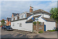
Linden House
Joint residential and doctors' surgery in Upper Fairfield Road.
Image: © Ian Capper
Taken: 6 Aug 2019
0.02 miles
5
Fairfield House
The rear of Fairfield House, a 2017 rebuild of a late 19th Century building on the corner of Fairfield Road and Upper Fairfield Road, as seen from the latter. The previous building was a social club, itself formed out of a large Victorian house of the same name (which maps suggest dated originally from the mid 19th Century or earlier).
Image: © Ian Capper
Taken: 20 Nov 2019
0.03 miles
6

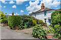
26 Middle Road
Late 18th/early 19th Century house in Middle Road. Grade II listed - see www.historicengland.org.uk/listing/the-list/list-entry/1378207.
Image: © Ian Capper
Taken: 6 Jun 2019
0.03 miles
7
26 Middle Road
Late 18th/early 19th Century house in Middle Road. Grade II listed - see www.historicengland.org.uk/listing/the-list/list-entry/1378207.
Image: © Ian Capper
Taken: 6 Jun 2019
0.03 miles
8
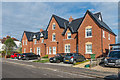
The Oaks
Block of 4 flats in Fairfield Road, built in 2017 as part of the redevelopment of the former Working Men's Club in Upper Fairfield Road, now also since replaced with housing. The flats are operated by The Grange, a disability charity based in Bookham. In the background is Fraser Court, an earlier redevelopment of part of the same site.
Image: © Ian Capper
Taken: 20 Nov 2019
0.03 miles
9
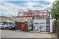
New flats
New flats under construction in Upper Fairfield Road, on the site of the former Fairfield Works.
Image: © Ian Capper
Taken: 6 Aug 2019
0.03 miles
10
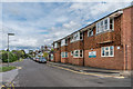
Fraser Court
Block of 4 flats in Fairfield Road built on the site of part of the former Working Men's Club in Upper Fairfield Road, now also since replaced with housing. The plaque on the front reads "SH 2013", SH presumably referring to the builder, Stonecot Homes.
Image: © Ian Capper
Taken: 20 Nov 2019
0.04 miles