IMAGES TAKEN NEAR TO
Gravel Hill, LEATHERHEAD, KT22 7HG
Introduction
This page details the photographs taken nearby to Gravel Hill, KT22 7HG by members of the Geograph project.
The Geograph project started in 2005 with the aim of publishing, organising and preserving representative images for every square kilometre of Great Britain, Ireland and the Isle of Man.

There are currently over 7.5m images from over14,400 individuals and you can help contribute to the project by visiting https://www.geograph.org.uk
Image Map
Images are licensed for reuse under creativecommons.org/licenses/by-sa/2.0
Notes
- Clicking on the map will re-center to the selected point.
- The higher the marker number, the further away the image location is from the centre of the postcode.
Image Listing (511 Images Found)
Images are licensed for reuse under creativecommons.org/licenses/by-sa/2.0
Image
Details
Distance
1
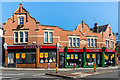
Road Junction in Leatherhead, Surrey
One of the more "interesting" junctions. Clockwise, from the left are Bull Hill (which splits just out of picture), Leret Way, and North Street. The left branch of Bull Hill feeds into Station Road, and forms part of a one-way system.
As capable as the next person when it comes to shooting a bad photograph, sometimes I surprise myself. With the camera on a monopod, and using a standard lens, I wanted to use the red brick building ( I think it is a Medical Centre) as the backdrop. This was a quick "grab" shot between passing cars, and I was standing at a bus stop. Curious to see how close I was to correct orientation in this photograph, I enlarged it to find that I was spot-on!
Image: © Peter Trimming
Taken: 10 Jul 2009
0.00 miles
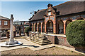
2
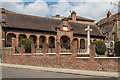
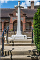
Leatherhead War Memorial
War memorial unveiled in 1921, situated on the corner of North Street and Gravel Hill. Grade II listed - see www.historicengland.org.uk/listing/the-list/list-entry/1028627.
Image: © Ian Capper
Taken: 30 Apr 2019
0.01 miles
3
Leatherhead War Memorial
War memorial unveiled in 1921, situated on the corner of North Street and Gravel Hill. Grade II listed - see www.historicengland.org.uk/listing/the-list/list-entry/1028627.
Image: © Ian Capper
Taken: 16 Jul 2019
0.01 miles
4
Leatherhead War Memorial
War memorial unveiled in 1921, situated on the corner of North Street and Gravel Hill. Grade II listed - see www.historicengland.org.uk/listing/the-list/list-entry/1028627.
Image: © Ian Capper
Taken: 11 Apr 2019
0.01 miles
5
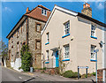
Gravel Hill
Buildings on Gravel Hill. The one on the left, nos 16 - 18, has a date plaque of 1799 and is grade II listed - see www.historicengland.org.uk/listing/the-list/list-entry/1378204.
Image: © Ian Capper
Taken: 11 Apr 2019
0.01 miles
6
Leatherhead War Memorial
War memorial unveiled in 1921, situated on the corner of North Street and Gravel Hill. Grade II listed - see www.historicengland.org.uk/listing/the-list/list-entry/1028627.
Image: © Ian Capper
Taken: 6 Jun 2019
0.01 miles
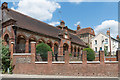
7
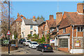
Gravel Hill
Looking up Gravel Hill from North Street. The nearest building is Sweech House, originally three buildings, with the nearest section thought to date from the late 15th Century, the other parts from the 16th Century. It is now used for by a firm of solicitors. Grade II listed - see www.historicengland.org.uk/listing/the-list/list-entry/1028622.
Image: © Ian Capper
Taken: 10 Apr 2019
0.01 miles
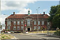
8
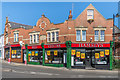
The Approach
Building on North Street, where it meets Station Road and Bull Hill, built in 1905.
Image: © Ian Capper
Taken: 10 Apr 2019
0.01 miles
9
The Approach
Building on North Street, where it meets Station Road and Bull Hill, built in 1905.
Image: © Ian Capper
Taken: 10 Apr 2019
0.01 miles
10
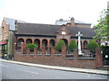
Leatherhead War Memorial
Cross and memorial garden with cloister on North Street in the town centre.
http://www.visitleatherhead.com/
Image: © Colin Smith
Taken: 29 May 2011
0.01 miles