IMAGES TAKEN NEAR TO
Belmont Road, LEATHERHEAD, KT22 7DX
Introduction
This page details the photographs taken nearby to Belmont Road, KT22 7DX by members of the Geograph project.
The Geograph project started in 2005 with the aim of publishing, organising and preserving representative images for every square kilometre of Great Britain, Ireland and the Isle of Man.

There are currently over 7.5m images from over14,400 individuals and you can help contribute to the project by visiting https://www.geograph.org.uk
Image Map
Images are licensed for reuse under creativecommons.org/licenses/by-sa/2.0
Notes
- Clicking on the map will re-center to the selected point.
- The higher the marker number, the further away the image location is from the centre of the postcode.
Image Listing (393 Images Found)
Images are licensed for reuse under creativecommons.org/licenses/by-sa/2.0
Image
Details
Distance
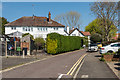
1
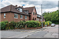
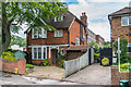
Holly Court
Retirement housing on Emlyn Lane/Belmont Road completed in 1987. This is the part facing onto Belmont Road. From 1926 to 1969 the part facing onto Emlyn Lane (see Image) was the site of Leatherhead Fire Station. The name would seem to come from that of a house in Belmont Road, demolished for the development, called The Hollies.
Image: © Ian Capper
Taken: 11 Jun 2019
0.01 miles
2
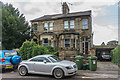
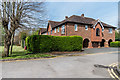
Mole Villas
Semi-detached late Victorian villas at 1 - 2 Belmont Road.
Image: © Ian Capper
Taken: 7 Aug 2019
0.02 miles
3
Mole Villas
Late Victorian semi-detached villas on Belmont Road.
Image: © Ian Capper
Taken: 11 Jun 2019
0.03 miles
4
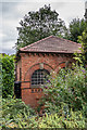
Sewage pumping station
Former sewage pumping station alongside Waterway Road.
Image: © Ian Capper
Taken: 8 Aug 2019
0.03 miles
5
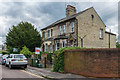
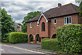
Belmont House
Edwardian house on Belmont Road.
Image: © Ian Capper
Taken: 11 Jun 2019
0.03 miles
6
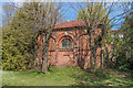
Sewage pumping station
Former sewage pumping station alongside Waterway Road.
Image: © Ian Capper
Taken: 11 Apr 2019
0.03 miles
7
Holly Court
Retirement housing on Emlyn Lane/Belmont Road completed in 1987. From 1926 to 1969 the part facing onto Emlyn Lane (as seen here) was the site of Leatherhead Fire Station. The name would seem to come from that of a house in Belmont Road, demolished for the development, called The Hollies.
Image: © Ian Capper
Taken: 11 Jun 2019
0.03 miles
8
Holly Court
Retirement housing on Emlyn Lane/Belmont Road completed in 1987. From 1926 to 1969 the part facing onto Emlyn Lane (as seen here) was the site of Leatherhead Fire Station. The name would seem to come from that of a house in Belmont Road, demolished for the development, called The Hollies.
Image: © Ian Capper
Taken: 18 Apr 2019
0.04 miles
9
Emlyn Lane
Looking up Emlyn Lane to its corner with Belmont Road. Old maps show the road to have been called River Lane, with the route originally being a footpath.
Image: © Ian Capper
Taken: 11 Apr 2019
0.04 miles
10
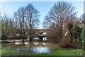
River Mole in flood
The River Mole in flood after a period of heavy rain over the previous few days, seen from Leatherhead Bridge. In the background is the bridge carrying Waterway Road over the river and behind its that carrying the Leatherhead to Dorking railway.
Image: © Ian Capper
Taken: 21 Dec 2019
0.04 miles