IMAGES TAKEN NEAR TO
Kingston Road, LEATHERHEAD, KT22 7BN
Introduction
This page details the photographs taken nearby to Kingston Road, KT22 7BN by members of the Geograph project.
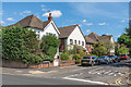
The Geograph project started in 2005 with the aim of publishing, organising and preserving representative images for every square kilometre of Great Britain, Ireland and the Isle of Man.

There are currently over 7.5m images from over14,400 individuals and you can help contribute to the project by visiting https://www.geograph.org.uk
Image Map
Images are licensed for reuse under creativecommons.org/licenses/by-sa/2.0
Notes
- Clicking on the map will re-center to the selected point.
- The higher the marker number, the further away the image location is from the centre of the postcode.
Image Listing (207 Images Found)
Images are licensed for reuse under creativecommons.org/licenses/by-sa/2.0
Image
Details
Distance
1
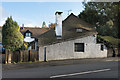
Bradmere Cottage
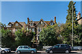
Cottage on Kingston Road. It is shown on the 1869 1:2,500 map.
Image: © Ian Capper
Taken: 14 Nov 2019
0.01 miles
2
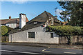
Bradmere Cottage
Cottage on Kingston Road. It is shown on the 1869 1:2,500 map. On the corner on the tight of the building by the pavement is a sundial with the inscription "I count the bright hours only MCMLXIII".
Image: © Ian Capper
Taken: 14 Nov 2019
0.01 miles
3
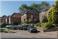
Kingston Road
c1940/50s housing on Kingston Road, built on the land of a large house on called Oak Hall (previously Hill Side).
Image: © Ian Capper
Taken: 18 Sep 2019
0.03 miles
4
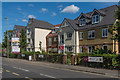
Churchill Retirement Living
Retirement apartment complex on Kingston Road completed in 2019, built on the site of the former Leatherhead Police Station.
Image: © Ian Capper
Taken: 5 Sep 2019
0.03 miles
5
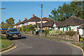
Park Rise
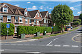
Road originally developed in 1906, following the filling in of a pond, Bradmere Pond. Old maps show the centre of the pond to have been at this junction, with Kingston Road (in the foreground) a relatively narrow track, and it seems that its removal was needed to allow the road to be widened. Originally only the top end of Park Rise was developed, with the rest following in the mid 20th Century. Hill Rise Court, on the left, was a 2002 subsequent redevelopment of the corner site.
Image: © Ian Capper
Taken: 5 Sep 2019
0.04 miles
6
27a and 29 - 31 Kingston Road
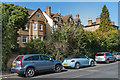
Two houses on Kingston Road. Nos 29 - 31, on the left, is a pair of semi-detached Victorian houses marked on the 1869 1:2,500 map. No 27a is much more recent.
Image: © Ian Capper
Taken: 18 Sep 2019
0.05 miles
7
27a and 29 - 31 Kingston Road
Two houses on Kingston Road. Nos 29 - 31, on the left, is a pair of semi-detached Victorian houses marked on the 1869 1:2,500 map. No 27a is much more recent.
Image: © Ian Capper
Taken: 18 Sep 2019
0.05 miles
8
Petrol Station
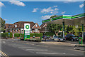
BP Petrol Station on Kingston Road, by its junction with Park Rise. This junction was originally the site of a pond, Bradmere Pond, which was filled in in 1906. Old maps show the centre of the pond to have been at this junction, with Kingston Road (in the foreground) a relatively narrow track, and it seems that its removal was needed to allow the road to be widened. Originally only the top end of Park Rise was developed, and this site was initially undeveloped. A building is shown on the 1939 1:2,500 map, with later editions marking it (with enlargement) as a garage. Hill Rise Court, in the left background, was a 2002 subsequent redevelopment of the corner site.
Image: © Ian Capper
Taken: 5 Sep 2019
0.05 miles
9
Kingston Avenue
Road between Kingston Road and St John's Avenue first laid out in the early 1900s.
Image: © Ian Capper
Taken: 5 Sep 2019
0.06 miles
10
Oaks Close
Cul-de-sac of which the southern section, seen here, was first developed in the c1930s, before later being extended northwards.
Image: © Ian Capper
Taken: 13 Sep 2019
0.06 miles