IMAGES TAKEN NEAR TO
Fairoak Lane, LEATHERHEAD, KT22 0TN
Introduction
This page details the photographs taken nearby to Fairoak Lane, KT22 0TN by members of the Geograph project.
The Geograph project started in 2005 with the aim of publishing, organising and preserving representative images for every square kilometre of Great Britain, Ireland and the Isle of Man.

There are currently over 7.5m images from over14,400 individuals and you can help contribute to the project by visiting https://www.geograph.org.uk
Image Map
Images are licensed for reuse under creativecommons.org/licenses/by-sa/2.0
Notes
- Clicking on the map will re-center to the selected point.
- The higher the marker number, the further away the image location is from the centre of the postcode.
Image Listing (10 Images Found)
Images are licensed for reuse under creativecommons.org/licenses/by-sa/2.0
Image
Details
Distance
1
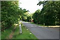
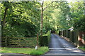
Stokesheath Road
Stokesheath Road from just north of its junction with Fairoak Lane. The road is private, giving access to an extensive Crown Estate development of up-market housing. Many of these Crown Estate roads are either gated, or gated at one end to prevent through traffic. However, the gates here have long since been removed, and replaced with a gate adjacent to Image about 500m to the north, so that Stokesheath Road is now in two parts, both dead-ends. The road has recently been recorded as a public bridleway, so that riders can gain access via Stokesheath Road and Queen's Drive onto Oxshott Heath.
Image: © Hugh Craddock
Taken: 9 Jul 2011
0.09 miles
2
Stokes Heath Road, Oxshott
Typical suburban road within the stockbroker belt of Surrey
Image: © David Howard
Taken: 19 Apr 2010
0.10 miles
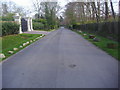
3
Montrose Gardens
The end of Montrose Gardens, a cul-de-sac on the Oxshott Crown Estate. Or not quite the end: visible to the left of the gates into The Willows is a gap between the hedges, which is the rather overgrown eastern terminus of an alleyway linking Montrose Gardens to Broomfield Ride. Given the character of the estate, it's hardly surprising that the alleyway does not seem to be greatly used.
Image: © Hugh Craddock
Taken: 24 Jul 2013
0.17 miles
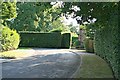
4
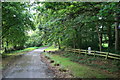
Broomfield Ride
Entrance to Broomfield Ride off Fair Oak Lane: this entrance is closed by electronically operated gates to prevent unauthorised through traffic.
Image: © Hugh Craddock
Taken: 24 Jul 2013
0.19 miles
5
Entrance to Prince's Coverts
Forest ride off Fairoak Lane into Prince's Coverts. In the C19, this ride formed the western boundary of Brickyard Plantation, but the adjacent land on both sides (formerly Crown Estate land) has long since been developed into very upmarket housing, leaving just this finger of the forest reaching north to the road. Virtually the entire width of the ride is now overgrown, leaving just a narrow path down the right hand side in the photo: moreover, the gate is kept locked, and the path shows little signs of use. To the right of the ride is the drive to Meadow House.
Image: © Hugh Craddock
Taken: 9 Jul 2011
0.20 miles
6
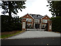
Oxshott - Recent Rebuilt House on Leys Road
This is one very large detached house or small mansion.
Image: © James Emmans
Taken: 7 Aug 2016
0.22 miles
7
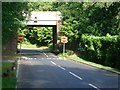
Railway bridge over Heath Road
Looking north-west.
Image: © Andrew Longton
Taken: 8 Sep 2005
0.22 miles
8
Coal Tax Post, Stokesheath Road
Coal Tax Post now in the private garden of Foxholes. This is one of four such posts, listed grade II, in Stokesheath Road.
Image: © Hugh Craddock
Taken: 9 Jul 2011
0.22 miles
9
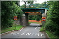
Heath Road railway bridge
Heath Road descends from Warren Lane parallel to the New Guildford line, before turning a right-angle to pass under the railway and out to Fairoak Lane. Heath Road is one-way beyond the bridge. The bridge has been recently replaced: compare with Image, which shows that the upper part of the abutments has been rebuilt.
Image: © Hugh Craddock
Taken: 10 Aug 2013
0.24 miles
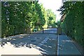
10
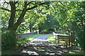
Stokesheath Road railway bridge
Bridge over the Guildford to Surbiton railway line, carrying the private Stokesheath Road on the Crown Estate. The road is severed here by a locked gate, so that both ends of Stokesheath Road are dead-ends. However, the bridle gate on the right gives access for pedestrians, cyclists and horse riders along the road between Fairoak Lane and Oxshott Heath, as this is public bridleway Esher 90.
Image: © Hugh Craddock
Taken: 9 Jul 2011
0.25 miles