IMAGES TAKEN NEAR TO
Kings Warren, LEATHERHEAD, KT22 0PE
Introduction
This page details the photographs taken nearby to Kings Warren, KT22 0PE by members of the Geograph project.
The Geograph project started in 2005 with the aim of publishing, organising and preserving representative images for every square kilometre of Great Britain, Ireland and the Isle of Man.

There are currently over 7.5m images from over14,400 individuals and you can help contribute to the project by visiting https://www.geograph.org.uk
Image Map
Images are licensed for reuse under creativecommons.org/licenses/by-sa/2.0
Notes
- Clicking on the map will re-center to the selected point.
- The higher the marker number, the further away the image location is from the centre of the postcode.
Image Listing (12 Images Found)
Images are licensed for reuse under creativecommons.org/licenses/by-sa/2.0
Image
Details
Distance
1
Bridleway off Queen's Drive
Public bridleway Esher 90 connects Queen's Drive with Oxshott Heath, which lies at the end of the alleyway. The bridleway continues along Queen's Drive and Stokesheath Road to Fairoak Lane.
Image: © Hugh Craddock
Taken: 9 Jul 2011
0.12 miles
2
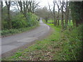
Stokes Heath Road North
The road has been divided in two, this end is Crown Estate
Image: © David Howard
Taken: 25 Apr 2010
0.16 miles
3
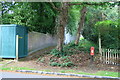
Security on the Oxshott residential estate
Houses on the former Crown Estate at Oxshott apparently demand special security measures, such as this one above the fence at the back of the property (Beaulieu) along the edge of Oxshott Heath.
Image: © Hugh Craddock
Taken: 10 Aug 2013
0.16 miles
4
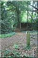
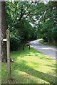
Bridleway to Queen's Drive
The alleyway ahead marks the start of public bridleway Esher 90, from Oxshott Heath to Queen's Drive, then along the Drive and Stokesheath Road, to Fairoak Lane. The post in the foreground does not point to the alleyway, but to the south, along a 'permissive' bridleway on the Heath which crosses Heath Road and Warren Lane to connect with public bridleway Esher 63a near Oxshott station.
Image: © Hugh Craddock
Taken: 9 Jul 2011
0.17 miles
5
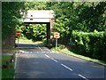
Railway bridge over Heath Road
Looking north-west.
Image: © Andrew Longton
Taken: 8 Sep 2005
0.17 miles
6
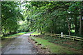
Queen's Drive
View south along Queen's Drive, from the junction with Stokesheath Road (North). These are both private roads, but both are also a public bridleway Esher 90, which gives access between Prince's Coverts and Oxshott Heath without the need to negotiate the busy Fairoak Lane/Warren Lane junction.
Image: © Hugh Craddock
Taken: 9 Jul 2011
0.17 miles
7
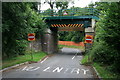
Heath Road railway bridge
Heath Road descends from Warren Lane parallel to the New Guildford line, before turning a right-angle to pass under the railway and out to Fairoak Lane. Heath Road is one-way beyond the bridge. The bridge has been recently replaced: compare with Image, which shows that the upper part of the abutments has been rebuilt.
Image: © Hugh Craddock
Taken: 10 Aug 2013
0.18 miles
8
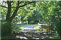
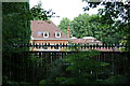
Stokesheath Road railway bridge
Bridge over the Guildford to Surbiton railway line, carrying the private Stokesheath Road on the Crown Estate. The road is severed here by a locked gate, so that both ends of Stokesheath Road are dead-ends. However, the bridle gate on the right gives access for pedestrians, cyclists and horse riders along the road between Fairoak Lane and Oxshott Heath, as this is public bridleway Esher 90.
Image: © Hugh Craddock
Taken: 9 Jul 2011
0.20 miles
9
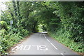
Heath Road
Heath Road, looking uphill towards the junction with Queen's Drive. The road is one-way, with a cycle track (also one-way) marked down the near side.
Image: © Hugh Craddock
Taken: 10 Aug 2013
0.21 miles
10
Coal Tax Post, Stokesheath Road
Coal Tax Post now in the private garden of Foxholes. This is one of four such posts, listed grade II, in Stokesheath Road.
Image: © Hugh Craddock
Taken: 9 Jul 2011
0.22 miles