IMAGES TAKEN NEAR TO
Randalls Road, LEATHERHEAD, KT22 0AD
Introduction
This page details the photographs taken nearby to Randalls Road, KT22 0AD by members of the Geograph project.
The Geograph project started in 2005 with the aim of publishing, organising and preserving representative images for every square kilometre of Great Britain, Ireland and the Isle of Man.

There are currently over 7.5m images from over14,400 individuals and you can help contribute to the project by visiting https://www.geograph.org.uk
Image Map
Images are licensed for reuse under creativecommons.org/licenses/by-sa/2.0
Notes
- Clicking on the map will re-center to the selected point.
- The higher the marker number, the further away the image location is from the centre of the postcode.
Image Listing (41 Images Found)
Images are licensed for reuse under creativecommons.org/licenses/by-sa/2.0
Image
Details
Distance
1
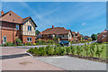
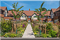
Henderson Crescent
Looking across Hartfield Road to Henderson Crescent, part of "The Farthings", an over 55 housing complex completed in 2018-9.
Image: © Ian Capper
Taken: 4 Jul 2019
0.06 miles
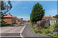
2
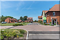
Hartfield Road
Housing on Hartfield Road, a development off Cleeve Road completed in 2018-9. The building on the right is in Henderson Crescent, part of "The Farthings", an over 55 housing complex.
Image: © Ian Capper
Taken: 4 Jul 2019
0.07 miles
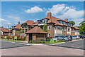
4
Henderson Crescent
Housing on Hartfield Road, part of "The Farthings", an over 55 housing complex completed in 2018-9.
Image: © Ian Capper
Taken: 16 May 2019
0.07 miles
5
Henderson Crescent
Housing on Hartfield Road, part of "The Farthings", an over 55 housing complex completed in 2018-9.
Image: © Ian Capper
Taken: 4 Jul 2019
0.08 miles
6
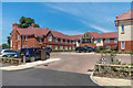
Hartfield House
Care home on Hartfield Road completed in 2018-9.
Image: © Ian Capper
Taken: 4 Jul 2019
0.08 miles
7
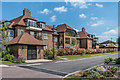
Reeves House
An apartment block on Hartfield Road, part of "The Farthings", an over 55 housing complex completed in 2018-9.
Image: © Ian Capper
Taken: 16 May 2019
0.10 miles
8
Reeves House
An apartment block on Hartfield Road, part of "The Farthings", an over 55 housing complex completed in 2018-9.
Image: © Ian Capper
Taken: 16 May 2019
0.10 miles
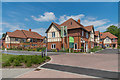
9
Hartfield Road
Looking along Hartfield Road, a development off Cleeve Road completed in 2018-9.
Image: © Ian Capper
Taken: 4 Jul 2019
0.10 miles
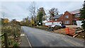
10
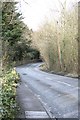
Randalls Road
Randalls Road, between nos. 54 and 69 (there are no intervening house numbers: it seems numbers along this stretch of Randalls Road were allocated on the basis that all possible sites would be developed). This stretch of Randalls Road, between Cleeve Road and River Lane, is the unimproved Randalls Lane, and remains narrow with an equally narrow pavement.
Image: © Hugh Craddock
Taken: 2 Mar 2014
0.12 miles