IMAGES TAKEN NEAR TO
Ashtead Woods Road, ASHTEAD, KT21 2ET
Introduction
This page details the photographs taken nearby to Ashtead Woods Road, KT21 2ET by members of the Geograph project.
The Geograph project started in 2005 with the aim of publishing, organising and preserving representative images for every square kilometre of Great Britain, Ireland and the Isle of Man.

There are currently over 7.5m images from over14,400 individuals and you can help contribute to the project by visiting https://www.geograph.org.uk
Image Map
Images are licensed for reuse under creativecommons.org/licenses/by-sa/2.0
Notes
- Clicking on the map will re-center to the selected point.
- The higher the marker number, the further away the image location is from the centre of the postcode.
Image Listing (6 Images Found)
Images are licensed for reuse under creativecommons.org/licenses/by-sa/2.0
Image
Details
Distance
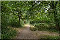
3
Path, Ashstead Common
One of many paths on the largely wooded Ashstead Common, which was bought by the City of London for the benefit of the people.
Image: © Robin Webster
Taken: 14 Nov 2011
0.12 miles
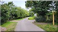
4
Ashtead Common
Path junction in Ashtead Common.
Image: © Ian Capper
Taken: 20 Jul 2018
0.15 miles
5
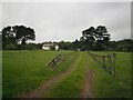
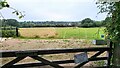
Around Ashtead Woods Road
Pasture land, now occupied primarily by horses, surrounds one of a number of large houses that were built along Ashtead Woods Road in the late C19th/early C20th. The bank of trees beyond reveals the edge of Ashtead Common. Considering the location - on the northern edge of Ashtead, less than half a mile from the M25 and the border with Greater London - the scene is remarkably rural in character.
Image: © Thomas Grant
Taken: 9 May 2007
0.16 miles
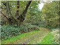
6
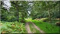
Woodland track on Ashtead Common
495 acres common and national nature reserve, owned and run by the City of London Corporation. SSSI status due to rear invertebrates and an important breeding area for birds
Image: © James Emmans
Taken: 4 Sep 2021
0.20 miles