IMAGES TAKEN NEAR TO
Park Drive, ASHTEAD, KT21 1JB
Introduction
This page details the photographs taken nearby to Park Drive, KT21 1JB by members of the Geograph project.
The Geograph project started in 2005 with the aim of publishing, organising and preserving representative images for every square kilometre of Great Britain, Ireland and the Isle of Man.

There are currently over 7.5m images from over14,400 individuals and you can help contribute to the project by visiting https://www.geograph.org.uk
Image Map
Images are licensed for reuse under creativecommons.org/licenses/by-sa/2.0
Notes
- Clicking on the map will re-center to the selected point.
- The higher the marker number, the further away the image location is from the centre of the postcode.
Image Listing (96 Images Found)
Images are licensed for reuse under creativecommons.org/licenses/by-sa/2.0
Image
Details
Distance
1
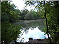
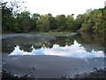
Ashtead Park Pond
Round tree-fringed pond in the park which was once a deer park, owned by Sir Richard Howard (1680).
Image: © Colin Smith
Taken: 29 May 2011
0.06 miles
2
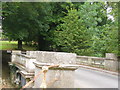
Ornamental Bridge, Ashtead Park
Stone balustrades and a low arched bridge take the old carriage road into Ashtead Park, once the manor of the Howards.
Image: © Colin Smith
Taken: 29 May 2011
0.07 miles
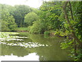
3
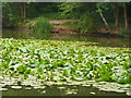
Lily Pond in Ashtead Park
The northern part of the Howard's old manorial estate is open to the public. It has ponds and woodland walks.
Image: © Colin Smith
Taken: 29 May 2011
0.08 miles
4
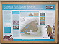
Ashtead Park Nature Reserve
Information board at the south-west entrance into the woodland. The park was created for Sir Richard howard in 1680.
Image: © Colin Smith
Taken: 29 May 2011
0.10 miles
6
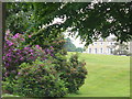
Ashtead Park
School grounds in the southern part of Ashtead Park. In the distance is the City of London Freemen's School.
Image: © Colin Smith
Taken: 29 May 2011
0.14 miles
8
Rookery Hill, Ashtead
Driveway into Ashtead Park, once the manor of the Howards. The estate was created in 1680.
Image: © Colin Smith
Taken: 29 May 2011
0.15 miles