1
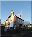
The Thoroughfare
Track linking Breech Lane with Chequers Lane. On the left is Little Lodge (which first appears in the 1955-71 1:2,500 map, replacing an earlier pair of semi-detached cottages first shown in the 1896 edition) and the furthest building is a semi-detached pair, Mead Cottages, also first shown in the 1896 1:2,500 map. The pair in the middle, Leith Cottages, is more recent. Planning for them was approved in 2010 and according to the Officer's report on the planning application for the cottages, these replaced a single storey club building, Walton Comrades Club, built c1950 but unused from c2000 (although a building marked "club" is shown in the 1935 1:2,500 map, suggesting it could have been earlier than this).
Image: © Ian Capper
Taken: 10 Jan 2020
0.01 miles
2
Walton on the Hill: St Peter's Cottage (2)
To be found in Breech Lane, just across the road from the parish church.
The proportions - tall and narrow - are quite unusual in a weather-boarded cottage, and (along with the barge-boards at the gables) remind me somewhat of a railway signal-box (circa 1850, say).
The cottage is extremely well-kept - not always the case with weather-boarded cottages. And while modern windows (double-glazed, I imagine) have been fitted, this has been done quite sensitively, without compromising the building's character.
Image: © Stefan Czapski
Taken: 5 Jan 2018
0.01 miles
3
Breech Lane
Houses on Breech Lane, Little Lodge on the left and 2 Breech Lane in the background. The former first appears in the 1955-71 1:2,500 map, replacing an earlier pair of semi-detached cottages first shown on the 1896 edition, with the latter first appearing on the 1896 edition.
Image: © Ian Capper
Taken: 10 Jan 2020
0.02 miles
4
Walton on the Hill: St Peter's Cottage (1)
A weather-boarded cottage just across the road from St Peter's church.
Image: © Stefan Czapski
Taken: 5 Jan 2018
0.02 miles
5
Walton on the Hill: St Peter's Cottage (3)
Seen from St Peter's churchyard.
Image: © Stefan Czapski
Taken: 5 Jan 2018
0.02 miles
6
Breech Lane
Houses on Breech Lane, 2 Breech Lane on the right and Little Lodge in the background. The former first appears on the 1896 1:2,500 map, with the latter in the 1955-71 edition, replacing an earlier pair of semi-detached cottages first shown in the 1896 edition.
Image: © Ian Capper
Taken: 10 Jan 2020
0.02 miles
7
The Green
Buildings on The Green. On the right are Marion Cottages, first shown on the 1935 1:2,500 map. Beyond that is 4 - 5 The Green, a late 19th Century pair of semi-detached cottages, then St Peter's Church Hall, and then 1 - 2 another late 19th Century pair of semi-detached cottages. In the left background is St Peter's Church.
Image: © Ian Capper
Taken: 10 Jan 2020
0.04 miles
8
The village green and church, Walton-on-the Hill
Image: © David Howard
Taken: 20 Feb 2012
0.04 miles
9
St Peter's Church Hall
Church hall to St Peter's Church, situated on The Green. Beyond is 1 - 2 The Green, a late 19th Century pair of semi-detached cottages.
Image: © Ian Capper
Taken: 10 Jan 2020
0.04 miles
10
1 - 2 The Green
Pair of late 19th Century semi-detached cottages on The Green. On the right is St Peter's Church Hall and beyond is 4 - 5 The Green, also late 19th Century.
Image: © Ian Capper
Taken: 10 Jan 2020
0.04 miles


