IMAGES TAKEN NEAR TO
Boxhill Road, TADWORTH, KT20 7PF
Introduction
This page details the photographs taken nearby to Boxhill Road, KT20 7PF by members of the Geograph project.
The Geograph project started in 2005 with the aim of publishing, organising and preserving representative images for every square kilometre of Great Britain, Ireland and the Isle of Man.

There are currently over 7.5m images from over14,400 individuals and you can help contribute to the project by visiting https://www.geograph.org.uk
Image Map
Images are licensed for reuse under creativecommons.org/licenses/by-sa/2.0
Notes
- Clicking on the map will re-center to the selected point.
- The higher the marker number, the further away the image location is from the centre of the postcode.
Image Listing (12 Images Found)
Images are licensed for reuse under creativecommons.org/licenses/by-sa/2.0
Image
Details
Distance
1
Underground Reservoir
Part of an underground reservoir that's clearly marked on Ordnance Survey maps.
Image: © Hywel Williams
Taken: 20 Jul 2005
0.11 miles
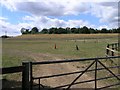
2
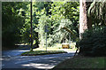
Entrance to Reservoirs
Off Boxhill Road.
Image: © Oast House Archive
Taken: 6 Oct 2010
0.13 miles
3
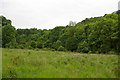
Fraser Down
Fraser Down was purchased by Surrey Wildlife Trust in 2008 after many years of negotiation with its owners. Although largely overrun with scrub, it has great potential as a link between the existing SWT reserve of Dawcombe, on the other side of the B2032 Pebblehill Road, and the former Betchworth Quarry, also managed by the SWT with the view to converting a landfilled quarry to downland. By restoring areas of the new reserve to open grassland, the aim is to provide stepping stones for chalkland specialists, such as the Silver Spotted Skipper butterfly, to move between sites, rather than being restricted to isolated pockets.
This photo was taken on a recorders’ evening, when the SWT invited members of the Surrey Botanical Society and other bodies to help build up a picture of the flora and fauna already on the site. It shows part of the upper section of the reserve, in an area less affected by scrub than the rest of the site, looking towards the woodland rings the western side of Pebble Combe.
Image: © Ian Capper
Taken: 3 Jun 2009
0.15 miles
4
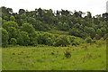
Fraser Down
Fraser Down was purchased by Surrey Wildlife Trust in 2008 after many years of negotiation with its owners. Although largely overrun with scrub, it has great potential as a link between the existing SWT reserve of Dawcombe, on the other side of the B2032 Pebblehill Road, and the former Betchworth Quarry, also managed by the SWT with the view to converting a landfilled quarry to downland. By restoring areas of the new reserve to open grassland, the aim is to provide stepping stones for chalkland specialists, such as the Silver Spotted Skipper butterfly, to move between sites, rather than being restricted to isolated pockets.
This photo was taken on a recorders’ evening, when the SWT invited members of the Surrey Botanical Society and other bodies to help build up a picture of the flora and fauna already on the site. It shows part of the upper section of the reserve, in an area less affected by scrub than the rest of the site. In the background is the existing SWT reserve of Dawcombe.
Image: © Ian Capper
Taken: 3 Jun 2009
0.17 miles
5
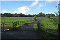
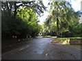
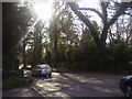
Pebble Coombe: Road junction
Straight on is the road to Box Hill: to the right the B2033 to Headley Common, and, eventually, Leatherhead.
Image: © Dr Neil Clifton
Taken: 9 Aug 2013
0.18 miles
6
Headley Common Road and Boxhill Road junction
Image: © Oast House Archive
Taken: 6 Oct 2010
0.20 miles
7
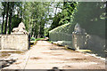
Headley Hall: Lions on guard
A pair of stone lions watch over the entrance to the driveway
Image: © Dr Neil Clifton
Taken: 9 Aug 2013
0.21 miles
8
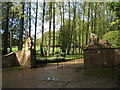
Lion protected entrance to Headley Grove
Image: © Oast House Archive
Taken: 6 Oct 2010
0.21 miles
9
Headley Common Road
By junction of Pebble Close
Image: © David Howard
Taken: 4 Apr 2011
0.23 miles
10
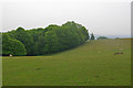
South of Boxhill Road
A rolling field just north of the scarp of the North Downs.
Image: © Ian Capper
Taken: 6 Jun 2010
0.24 miles