IMAGES TAKEN NEAR TO
Brighton Road, TADWORTH, KT20 6UQ
Introduction
This page details the photographs taken nearby to Brighton Road, KT20 6UQ by members of the Geograph project.
The Geograph project started in 2005 with the aim of publishing, organising and preserving representative images for every square kilometre of Great Britain, Ireland and the Isle of Man.

There are currently over 7.5m images from over14,400 individuals and you can help contribute to the project by visiting https://www.geograph.org.uk
Image Map
Images are licensed for reuse under creativecommons.org/licenses/by-sa/2.0
Notes
- Clicking on the map will re-center to the selected point.
- The higher the marker number, the further away the image location is from the centre of the postcode.
Image Listing (13 Images Found)
Images are licensed for reuse under creativecommons.org/licenses/by-sa/2.0
Image
Details
Distance
1
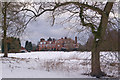
The Red Lodge
A large house on the edge of Banstead Heath. The snow cover is from a heavy fall earlier that week.
Image: © Ian Capper
Taken: 7 Feb 2009
0.01 miles
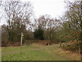
2
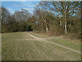
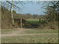
Bridleway on Banstead Heath
A view of the bridleway running from The Sportsman to Hogden Bottom near Red Lodge.
Image: © John Hilton
Taken: 15 Mar 2007
0.10 miles
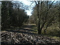
3
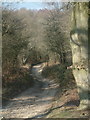
Bridleway near Red Lodge
This bridleway links The Sportsman with Hogden Bottom and Chipstead Lane. At this point the route is passing close to Red Lodge.
Image: © John Hilton
Taken: 15 Mar 2007
0.12 miles
4
A really high hedge
This hedge is around a house called The Red Lodge. It is surprising a gap has been left for the gate, which is unused. The grassland in the foreground may be owned by the house. Up to about the viewpoint, it is common land, but onwards, although not marked on the ground, it is not.
Image: © Robin Webster
Taken: 7 Aug 2010
0.12 miles
5
Rustic Barrier on Banstead Heath
This barrier is situated on Banstead Heath near Red Lodge. The view is Eastwards towards Lower Kingswood.
Image: © John Hilton
Taken: 15 Mar 2007
0.13 miles
6
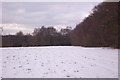
Banstead Heath
In the background can be seen the spire of St Andrew's Church, Kingswood. The snow cover is from a heavy fall earlier that week.
Image: © Ian Capper
Taken: 7 Feb 2009
0.18 miles
7
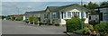
Holly Lodge Mobile Homes Park
View, looking North, from First Avenue of dwellings in the Holly Lodge Mobile Homes Park.
Image: © John Hilton
Taken: 15 Jun 2006
0.19 miles
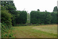
8
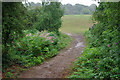
Path between open areas, Banstead Heath
This path crosses a wooded strip along a dip between cleared areas of heath. The cleared areas look interesting examples of somewhat acidic grassland, but no time to investigate, the rain was getting unpleasant.
Image: © Robin Webster
Taken: 7 Aug 2010
0.20 miles
9
Paths on Banstead Heath
Paths on Banstead Heath, in Surrey.
Image: © Malc McDonald
Taken: 9 Feb 2019
0.22 miles
10
Bridleway to Mogador
The bridleway from the Chipstead Lane entrance to Banstead Heath that leads to Mogador and The Sportsman PH.
Image: © John Hilton
Taken: 15 Mar 2007
0.22 miles