IMAGES TAKEN NEAR TO
Chipstead Lane, TADWORTH, KT20 6RH
Introduction
This page details the photographs taken nearby to Chipstead Lane, KT20 6RH by members of the Geograph project.
The Geograph project started in 2005 with the aim of publishing, organising and preserving representative images for every square kilometre of Great Britain, Ireland and the Isle of Man.

There are currently over 7.5m images from over14,400 individuals and you can help contribute to the project by visiting https://www.geograph.org.uk
Image Map
Images are licensed for reuse under creativecommons.org/licenses/by-sa/2.0
Notes
- Clicking on the map will re-center to the selected point.
- The higher the marker number, the further away the image location is from the centre of the postcode.
Image Listing (10 Images Found)
Images are licensed for reuse under creativecommons.org/licenses/by-sa/2.0
Image
Details
Distance
3
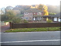
Large house on Chipstead Road, Mugswell
Image: © David Howard
Taken: 1 Nov 2015
0.05 miles
5
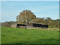
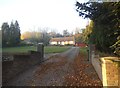
Stables above bridleway 119
A short part of the bridleway is used for vehicular access to these stables from Chipstead Lane.
Image: © Robin Webster
Taken: 24 Nov 2010
0.15 miles
6
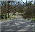
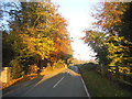
Millfield Lane, Lower Kingswood
Millfield Lane, Lower Kingswood at the junction with Chipstead Lane.
Image: © John Hilton
Taken: 11 Mar 2007
0.19 miles
7
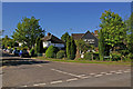
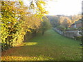
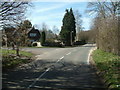
Monkswell Lane
At its junction with Chipstead Lane. Since the names Monkswell and Mugswell, to Monkswell Lane leads, are so similar, it might have been thought that the village name is a corruption of Monkswell. In fact Mugswell is a corruption, but not of Monkswell but of St Margaret's Well (originally shortened to Magswell), which still exists, in the garden of the Well House Inn (see Image).
These houses in Monkswell Lane are an isolated group, in what is otherwise open countryside.
Image: © Ian Capper
Taken: 23 May 2010
0.24 miles
9
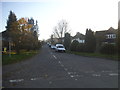
Monkswell Lane junction with Chipstead Lane
View showing Chipstead Lane heading towards Hogden Bottom.
Image: © John Hilton
Taken: 11 Mar 2007
0.25 miles
10
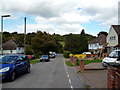
Kingswood: Monkswell Lane
Looking north, towards Hogarth Bottom
Image: © Dr Neil Clifton
Taken: 6 Oct 2013
0.25 miles