IMAGES TAKEN NEAR TO
Drive Spur, TADWORTH, KT20 6LR
Introduction
This page details the photographs taken nearby to Drive Spur, KT20 6LR by members of the Geograph project.
The Geograph project started in 2005 with the aim of publishing, organising and preserving representative images for every square kilometre of Great Britain, Ireland and the Isle of Man.

There are currently over 7.5m images from over14,400 individuals and you can help contribute to the project by visiting https://www.geograph.org.uk
Image Map
Images are licensed for reuse under creativecommons.org/licenses/by-sa/2.0
Notes
- Clicking on the map will re-center to the selected point.
- The higher the marker number, the further away the image location is from the centre of the postcode.
Image Listing (20 Images Found)
Images are licensed for reuse under creativecommons.org/licenses/by-sa/2.0
Image
Details
Distance
1
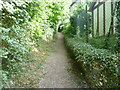
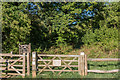
Footpath on the edge of Kingswood
This footpath passes between Chiphouse Wood and Kingswood. It then crosses Forest Drive and The Chase before reaching Outwood Lane. On the right are the fences of houses in Drive Spur. Chiphouse Wood is on the left.
Image: © Marathon
Taken: 14 Aug 2013
0.03 miles
2
Chiphouse Wood nature reserve: Western entrance
To the left and right
Image: © Dr Neil Clifton
Taken: 26 Sep 2014
0.04 miles
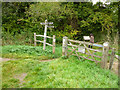
3
Entrance to Chiphouse Wood
This is on the edge of Kingswood. The footpath ahead passes through the main part of Chiphouse Wood and eventually reaches Outwood Lane. Chiphouse Wood is owned by the Woodland Trust. See http://www.woodlandtrust.org.uk/en/our-woods/Pages/wood-details.aspx?wood=4099#.UhvGLxusiSo for more information about Chiphouse Wood.
Image: © Marathon
Taken: 14 Aug 2013
0.04 miles
4
Forest Drive
Private road in Kingswood, this section developed in the c1920s.
Image: © Ian Capper
Taken: 5 Aug 2018
0.05 miles
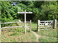
5
Chiphouse Wood
Entrance into the Woodland Trust's Chiphouse Wood.
Image: © Ian Capper
Taken: 5 Aug 2018
0.06 miles
6
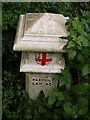
Coal tax post
Number 157 as listed at http://www.coaldutyposts.org.uk/images/pdf/Extant_Posts_Report.pdf , just east of Banstead bridleway 45 a little south of where it passes under the railway line up Chipstead valley.
Image: © Derek Harper
Taken: 12 Oct 2007
0.06 miles
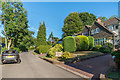
7
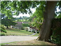
Houses in Kingswood
The houses in this area of Kingswood are certainly exclusive. This is the view from near the junction of Forest Drive with Drive Spur. This is at the upper end of Chipstead Valley and the back gardens of the houses reach down to the railway line while the other side of the valley gives a countryside outlook.
Image: © Marathon
Taken: 14 Aug 2013
0.06 miles
8
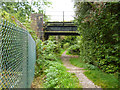
Bridleway under the railway
Looking south, the bridleway continues to meet the main road, Outwood Lane. The railway is the Tattenham Corner branch.
Image: © Dr Neil Clifton
Taken: 26 Sep 2014
0.08 miles
9
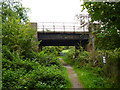
Bridleway under the railway
Looking north, the bridleway goes on to Read's Rest. The railway is the branch line to Tattenham Corner.
Image: © Dr Neil Clifton
Taken: 26 Sep 2014
0.08 miles
10
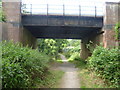
Railway bridge on the edge of Kingswood
A branch line along the Chipstead Valley from the Brighton Main Line was first projected in 1884. This scheme failed to take off. The line from Purley East Junction to Kingswood & Burgh Heath was eventually opened on 2nd November 1897 as a single track and this was doubled during 1899. The line finally reached Tattenham Corner on 4th June 1901 - Derby Day. The railway provides attractive views of Chipstead Valley and it is certainly one of the pleasantest rides within London Travelcard Zone 6, even though most of it is in Surrey.
This footpath leads from the outskirts of Kingswood, under the railway and on to meet Reads Rest Lane which eventually reaches Burgh Heath.
Image: © Marathon
Taken: 14 Aug 2013
0.08 miles