IMAGES TAKEN NEAR TO
St. Monicas Road, TADWORTH, KT20 6HA
Introduction
This page details the photographs taken nearby to St. Monicas Road, KT20 6HA by members of the Geograph project.
The Geograph project started in 2005 with the aim of publishing, organising and preserving representative images for every square kilometre of Great Britain, Ireland and the Isle of Man.

There are currently over 7.5m images from over14,400 individuals and you can help contribute to the project by visiting https://www.geograph.org.uk
Image Map
Images are licensed for reuse under creativecommons.org/licenses/by-sa/2.0
Notes
- Clicking on the map will re-center to the selected point.
- The higher the marker number, the further away the image location is from the centre of the postcode.
Image Listing (45 Images Found)
Images are licensed for reuse under creativecommons.org/licenses/by-sa/2.0
Image
Details
Distance
1
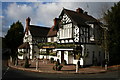
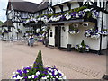
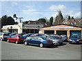
The 'Kingswood Arms', Surrey
The area around Kingswood could be described as wealthy, with houses priced mostly from £1 million upwards. This large public house therefore has to maintain a high quality of service. The former name of this house was 'The Pigeon Pair'.
Image: © Dr Neil Clifton
Taken: 14 Nov 2007
0.04 miles
2
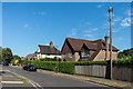
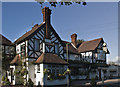
St Monica's Road
1930s(?) housing in St Monica's Road.
Image: © Ian Capper
Taken: 5 Aug 2018
0.05 miles
3
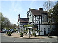
The Kingswood Arms public house, Kingswood
Image: © Stacey Harris
Taken: 11 Apr 2010
0.05 miles
4
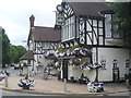
The Kingswood Arms
It must take a while to water all of these hanging baskets and tubs. For more information on the history of the pub see http://www.geograph.org.uk/photo/12844
Image: © Marathon
Taken: 14 Aug 2013
0.05 miles
5
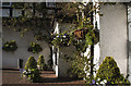
Flowers outside the Kingswood Arms
It must take a while to water all of these hanging baskets and tubs. For more information on the history of the pub see http://www.geograph.org.uk/photo/12844
Image: © Marathon
Taken: 14 Aug 2013
0.05 miles
6
The Kingswood Arms
The local bar and restaurant
Image: © Kurseong Carl
Taken: 1 May 2012
0.05 miles
8
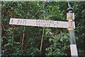
Old Direction Sign - Signpost by the B2032, Waterhouse Lane, Banstead
Annulus finial - 3 arms; Surrey halo by the B2032, in parish of Banstead (Reigate and Banstead District), Waterhouse Lane junction with Bonsor Drive and Morneals Road, near Kingswood Station, on verge.
Surveyed
Milestone Society National ID: SY_TQ2456
Image: © Milestone Society
Taken: 22 Sep 2009
0.06 miles
10
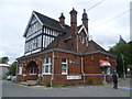
Kingswood station
A branch line along the Chipstead Valley from the Brighton Main Line was first projected in 1884. This scheme failed to take off. The line from Purley East Junction to Kingswood & Burgh Heath was eventually opened on 2nd November 1897 as a single track and this was doubled during 1899. The line finally reached Tattenham Corner on 4th June 1901 - Derby Day. The railway provides attractive views of Chipstead Valley and it is certainly one of the pleasantest rides within London Travelcard Zone 6, even though most of it is in Surrey.
The original station building seen here is on the up platform. Part of the building is still used by Southern, but the upper floors and part of the ground floor are used as offices for the Tudor Business Centre.
As stated above, Kingswood station originally opened in 1897 as Kingswood & Burgh Heath. It was the original terminus of the single-track line before it was extended to Walton-on-the-Hill in 1900 (now Tadworth) and Tattenham Corner a year later. A plaque inside the archway on the left was unveiled by The Bourne Society on 2nd November 1997 to celebrate the centenary of the Chipstead Valley Railway on November 1st 1897 (sic).
Image: © Marathon
Taken: 14 Aug 2013
0.07 miles