IMAGES TAKEN NEAR TO
Canons Lane, TADWORTH, KT20 6DD
Introduction
This page details the photographs taken nearby to Canons Lane, KT20 6DD by members of the Geograph project.
The Geograph project started in 2005 with the aim of publishing, organising and preserving representative images for every square kilometre of Great Britain, Ireland and the Isle of Man.

There are currently over 7.5m images from over14,400 individuals and you can help contribute to the project by visiting https://www.geograph.org.uk
Image Map
Images are licensed for reuse under creativecommons.org/licenses/by-sa/2.0
Notes
- Clicking on the map will re-center to the selected point.
- The higher the marker number, the further away the image location is from the centre of the postcode.
Image Listing (15 Images Found)
Images are licensed for reuse under creativecommons.org/licenses/by-sa/2.0
Image
Details
Distance
2
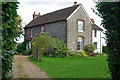
Canons Farmhouse
The farm buildings behind the house look very under-used, if not actually disused.
Image: © Robin Webster
Taken: 6 Oct 2010
0.02 miles
3
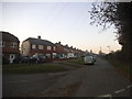
Canons Lane
Lane on the outskirts of Burgh Heath.
Image: © Ian Capper
Taken: 7 Oct 2022
0.07 miles
4
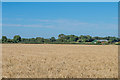
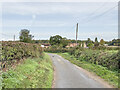
Field off Copt Hill Lane
Field off Copt Hill Lane. Reads Rest Lane runs across the other side of the field.
Image: © Ian Capper
Taken: 5 Aug 2018
0.16 miles
5
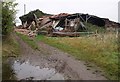
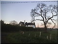
Dead fox and collapsed barn
A scene of some desolation on Reads Rest Lane. Could the two be connected? The barn actually looks in worse condition than it really is, as some of the rather fine flint walls are still intact - see Image This is looking up Banstead footpath 41 from its crossroads with the lane, beside Reads Rest Cottages.
Image: © Derek Harper
Taken: 12 Oct 2007
0.16 miles
6
Collapsed barn, Read's Rest
A close-up of the C18 flint and brick barn shown in Image, beside Banstead footpath 41. I suspect this is probably the barn referred to in the "list of buildings of architectural and historic interest in the Borough of Reigate and Banstead" (http://www.reigate-banstead.gov.uk/Images/List_Historical_InterestvOct06_tcm5-10503.pdf ), although it is described as being "north-east of Read's Rest Cottages", when it is in fact to the northwest. The preamble states "the Borough Council will seek to ensure the preservation of buildings on the local list", although I fear they will have their work cut out in this case. Some of the structure, however, remains intact.
Image: © Derek Harper
Taken: 12 Oct 2007
0.17 miles
8
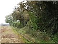
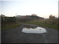
Footpath near Burgh Heath
Banstead footpath 41 runs along the edge of a field towards Read's Rest Lane.
Image: © Derek Harper
Taken: 12 Oct 2007
0.17 miles
9
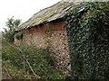
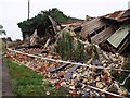
Barn wall, Read's Rest
The intact northern wall, largely of flint with a brick topping and slate roof, of the barn shown in Image
Image: © Derek Harper
Taken: 12 Oct 2007
0.17 miles